Alright, this is the thread for all the major cities and capitals of each nation on the TEP roleplay map. If you have a nation on the map, please post your city and/or capital’s name, location, size and urbanization levels. All of the information posted will be used to make a night map of Urth.
An animated night map of earth. Just need to know what your nation looks like from above.
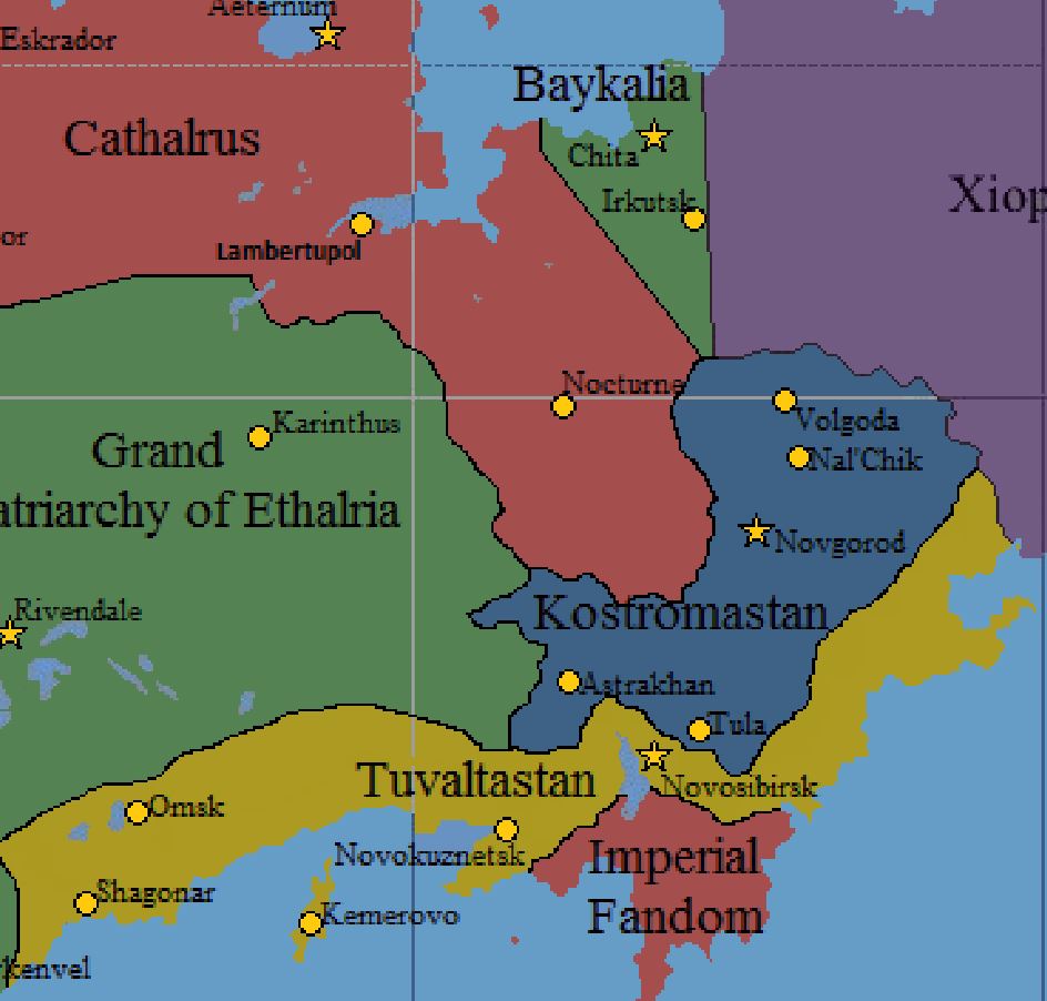
Tuvaltastan
Shagonar, pop. 11.3 Mill.: Urbanization of 91%
Novosibirsk, pop. 8.6 Mill.: Urbanization of 86%
Kemerovo, pop. 1 Mill.: Urbanization of 92%
Novokuznetsk, pop. 794,000: Urbanization of 72%
Omsk, pop. 620,000: Urbanization of 63%
Kostromastan
Novgorod, pop. 12.7 Mill.: Urbanization of 87%
Volgoda, pop. 4.3 Mill.: Urbanization of 95%
Nal’Chik, pop. 1.2 Mill.: Urbanization of 76%
Tula, pop. 1 Mill.: Urbanization of 100%
Astrakhan, pop. 638,500: Urbanization of 15%
Baykalia
Chita, pop. 1.47 Mill.: Urbanization of 100%
Irkutsk, pop. 1.48 Mill.: Urbanization of 100%
Tivot
Tarov, pop. 14.9 Mill.: Urbanization 100%
I plan on adding to this topic as soon as I have a more compatible device for images and the like. I’m also very interested in what a nighttime Urth would look like.
The Republic of Setzna
Urbanization: 0.3
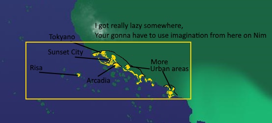
A cleaner, more organized map.
Major cities;
Sunset City
Population: 5.3 Million
Urbanization: 80%
Arcadia (Capital)
Population: 9.8 Million
Urbanization: 93%
Tokyano
Population: 13.64 Million
Urbanization: 97%
Risa
Population: 609,456 Thousand
Urbanization: 72%
New Alexandria
Population: 10.8 Million
Urbanization: 85%
Dolitz (Currently under UIRF control)
Population: 1.2 Million
Urbanization: 79%
Shinsu
Population: 2.9 Million
Urbanization: 83%
Normanza
Population: 6.5 Million
Urbanization: 84%
Setzna City
Population: 11.3 Million
Urbanization: 92%[edit_reason]More information added.[/edit_reason]
Pax cities line the coastline, with almost no settlement towards the interior. Pax’s coastline was once describes as a continuos metropolis spanning the gulf.
updated mah cities to include Tarov, Tivot
Here’s Mexregiona’s Major Settlements and Populations:
50,911,569 - Total Mexregionan Population
41,951,133 - Urban Population of Mexregiona
8,960,436 - Rural Population of Mexregiona
20,975,565 - Dropdatderp (on the map) (capital)
12,585,339 - Archopolis (on the map)
8,390,226 - Insulmin City (on the map) (seat of government)
3,956,822 - Civilmagnus (the peninsula located at about 48 N, 121 W) (if my coordinates are correct)
2,787,387 - Alter-native (west-northwest of Dropdatderp; on the opposite coast)
2,566,004 - Nouvelle Ville (on the land directly north of Sydonia)
637,384 - Flucivil (Somewhere on the southern coast of the lake between Mexregiona and Northwest Cascade.)
52,403 - Other Minor Towns
(Fun fact: Civilmagna was the unofficial capital of Mexregiona for quite a time.)
Also, for the night map, I’d like some spots of light in the ocean, especially around Dropdatderp and Civilmagna. These areas have high numbers of oil rigs, abandoned and not, and giant structures that are used for research purposes in the ocean. For reference, you can look up the Gulf of Mexico at night, from space. Perhaps adding these lights can make the image more realistic and comparable to Earth (not to be confused with Urth).