Think about it: the possibility of Urth having gone through a drifting of land and sea is very high. The question is, how would the planet have looked millions of years in the past? Perhaps maps can be made to demonstrate the drifting. I mean, I tried to do it myself at one point, but it proved too much for my feeble expertise. That’s why I brought it to the experts. This map could be a new project for the Cartographers of The Confederated East Pacific, and it could give a better understanding of the past of this fabulous place. Maybe you peeps can even manage to create a map that shows modern countries on the Past-Urth. ((Note: In my opinion, much of the driftings are obvious, such as Arcturia heading north in between Antilla and Yasteria Major, but a lot of others may have to be debated by the populace.))
EXAMPLES:
WARNING: BOTH IMAGES ARE MASSIVEhttp://eatrio.net/wp-content/uploads/2013/01/7.-Pangea_continents_and_oceans.jpg
http://img.gawkerassets.com/img/18pefyttaq6i1jpg/original.jpg
So, yeah. That’s all I have to say about that.
This is a very nice idea, however, it would probably take a very long time to make and I myself don’t have the expertise or experience to produce something like this.
— Begin quote from ____
This is a very nice idea, however, it would probably take a very long time to make and I myself don’t have the expertise or experience to produce something like this.
— End quote
Yes, the expertise will definitely be a problem; I’m also not of the achievement to do such things.
Do we even have the boundaries for tectonic plates?
I’m sure there is, but I can’t find it.
— Begin quote from ____
Do we even have the boundaries for tectonic plates?
I’m sure there is, but I can’t find it.
— End quote
I don’t think so, but we can always create some. (I guess.)
[spoiler]MEEEEEEEEEEEEEEEEEEEEEEEEEEEEEEEEEEEEEEEEEEEEEEEEEEEEEEEEEEEEEEEEEEEEEEEEEEEEEEEEEEEEEEEEEEEEEEEEEEEEEEEEEEEEEEEEEEEEEEEEEEEEEEEEEEEEEEEEEEEEEEEEEEEEEEEEEEEEEEEEEEEEEEEEEEEEEEEEEEEEEEEEEEEEEEEEEEEEEEEEEEEEEEEEEEEEEEEEEEEEEEX![/spoiler]
— Begin quote from ____
[spoiler]MEEEEEEEEEEEEEEEEEEEEEEEEEEEEEEEEEEEEEEEEEEEEEEEEEEEEEEEEEEEEEEEEEEEEEEEEEEEEEEEEEEEEEEEEEEEEEEEEEEEEEEEEEEEEEEEEEEEEEEEEEEEEEEEEEEEEEEEEEEEEEEEEEEEEEEEEEEEEEEEEEEEEEEEEEEEEEEEEEEEEEEEEEEEEEEEEEEEEEEEEEEEEEEEEEEEEEEEEEEEEEEX![/spoiler]
— End quote
Well, I wasn’t lying when I said I was going to be back.
MEX MEX MEX MEX MEX MEX MEX! MEEEEEEEEEEEEX!
yay
— Begin quote from ____
— Begin quote from ____
[spoiler]MEEEEEEEEEEEEEEEEEEEEEEEEEEEEEEEEEEEEEEEEEEEEEEEEEEEEEEEEEEEEEEEEEEEEEEEEEEEEEEEEEEEEEEEEEEEEEEEEEEEEEEEEEEEEEEEEEEEEEEEEEEEEEEEEEEEEEEEEEEEEEEEEEEEEEEEEEEEEEEEEEEEEEEEEEEEEEEEEEEEEEEEEEEEEEEEEEEEEEEEEEEEEEEEEEEEEEEEEEEEEEEX![/spoiler]
— End quote
Well, I wasn’t lying when I said I was going to be back.
— End quote
This quickly? Wow. You missed…not a lot, actually. Did you see the stuff in the RMB recently?
— Begin quote from ____
— Begin quote from ____
— Begin quote from ____
[spoiler]MEEEEEEEEEEEEEEEEEEEEEEEEEEEEEEEEEEEEEEEEEEEEEEEEEEEEEEEEEEEEEEEEEEEEEEEEEEEEEEEEEEEEEEEEEEEEEEEEEEEEEEEEEEEEEEEEEEEEEEEEEEEEEEEEEEEEEEEEEEEEEEEEEEEEEEEEEEEEEEEEEEEEEEEEEEEEEEEEEEEEEEEEEEEEEEEEEEEEEEEEEEEEEEEEEEEEEEEEEEEEEEX![/spoiler]
— End quote
— End quote
Well, I wasn’t lying when I said I was going to be back.
This quickly? Wow. You missed…not a lot, actually. Did you see the stuff in the RMB recently?
— End quote
I didn’t, due to my failure to see this post. I logged into NationStates today and came upon 1,300-something posts on the Board. Most of the time I don’t even bother anymore.
To switch the topic of conversation, however, I think that the only way this Continental Drift Idea is going to work is by allowing an experienced cartographer/smartypants to tinker with it. Don’t look at me; I can only make the most simple examples of cartography in digital form and I don’t plan on doing any large-scale constructions in the near future. So, that being said, I’d like to ask for any volunteers. If none can be found, I guess we’ll have to take an unorthodox route. Not to sound creepy or anything.
I can put it on my list of maps to do
Perhaps we can start with where the mountain ranges are in Urth? I figure plates or fault lines are probably hanging out around there
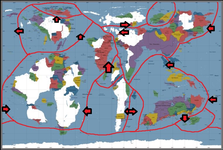
Here’s my take on the tectonic plates theory on Urth. It’s a VERY rough first go, so don’t take it as final ![]()
Don’t be afraid to put faults through land.
We’ll have to determine where the mountains and valleys are before putting faults through land
Pax/Veakyu border is a massive mountain range.
Pack, what’s going on in your western border, towards where my country is located? I have a mountain range there, but it doesn’t have to be on a current fault line
— Begin quote from ____
Here’s my take on the tectonic plates theory on Urth. It’s a VERY rough first go, so don’t take it as final ![]()
— End quote
-=-=-=-=-=-=-
Here is Earths Faults / Plate Tectonics …
Normal Atlantic Map View http://i.imgur.com/6jKG4Uf.png
Pacific Map View http://i.imgur.com/SXkwLmr.gif
-=-=-=-=-=-=-
If we do this, we really need the major mountain ranges of Urth to get an idea of where the Urth-Plates are.
— Begin quote from ____
Pack, what’s going on in your western border, towards where my country is located? I have a mountain range there, but it doesn’t have to be on a current fault line
— End quote
That area is all Savannah/Dry Grasslands. The range could be like what Chile has, and give a reason for Pax never pushing to the west coast there.