The California Tribes Protectorate is part of Wikichang … they annexed it at one point in one of their threads … if I remember correctly …
Read https://www.nationstates.net/nation=the_oan_isles/detail=factbook/id=211224 for more information.
The Oan Isles is hot, rainy and humid for most of the year. It is covered mostly in mountains and thick forests.
— Begin quote from ____
The California Tribes Protectorate is part of Wikichang … they annexed it at one point in one of their threads … if I remember correctly …

— End quote
That’s right Dragonia!, is now a self administered region within Wikichang, but is 100% tropical rainforest, some of my maps are before the California Tribes Protectorate thread, so that’s why may not show up haha. https://groups.tapatalk-cdn.com/smilies/52127/1536592180.3635-smiley.gif?ttinline=true
Can we have tectonic plates?
Is there a Pacific Ring of Fire of some sort?
— Begin quote from ____
Can we have tectonic plates?
— End quote
I would think so; that would explain the movement of the continents and oceans around the Urth.
— Begin quote from ____
Is there a Pacific Ring of Fire of some sort?
— End quote
That would make sense, considering there are so many islands in the Pacific Ocean, even some of them being under the jurisdiction of Mexregiona (A.K.A. the Arch Archipelago). These seem to be volcanic areas in the Pacific area. Just to be clear, this doesn’t take roleplay into account that much.
[spoiler]http://i.imgur.com/BXESikr.png
[/spoiler]
That’d definitely explain the “active” fault near the International Sealab.
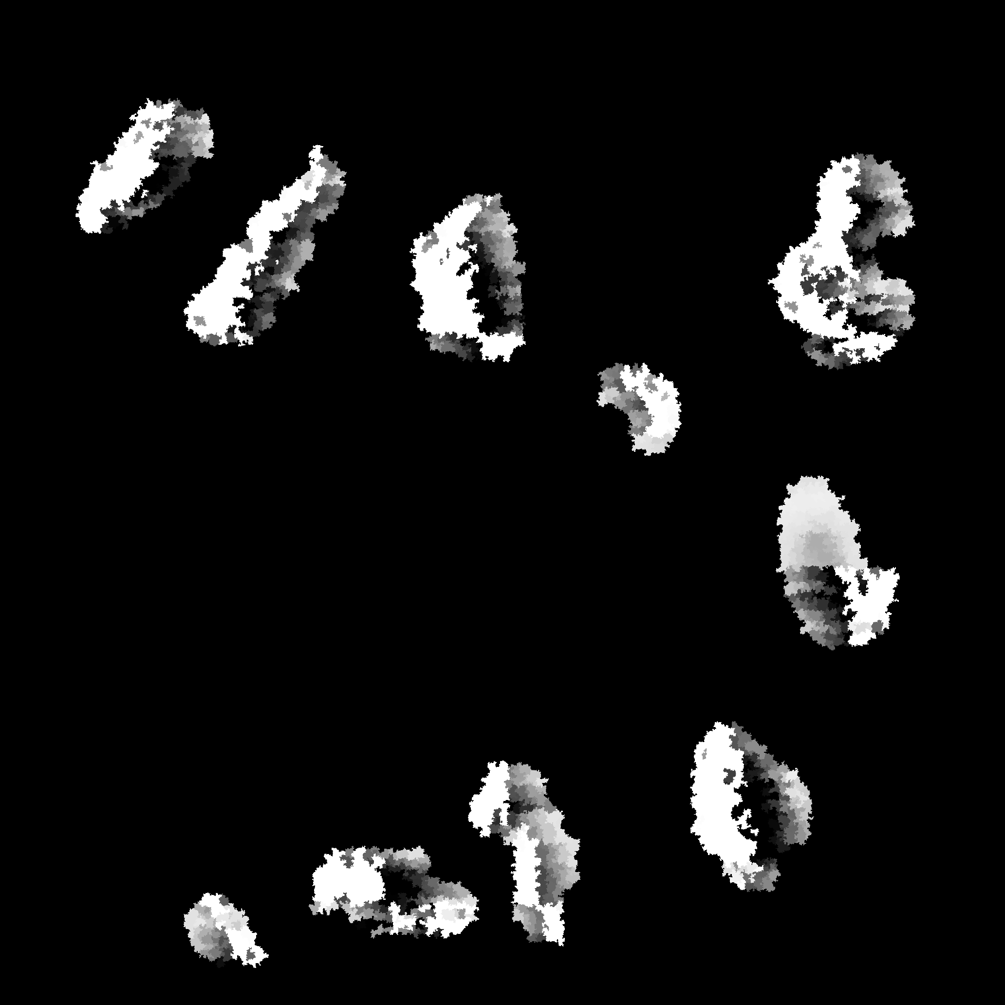
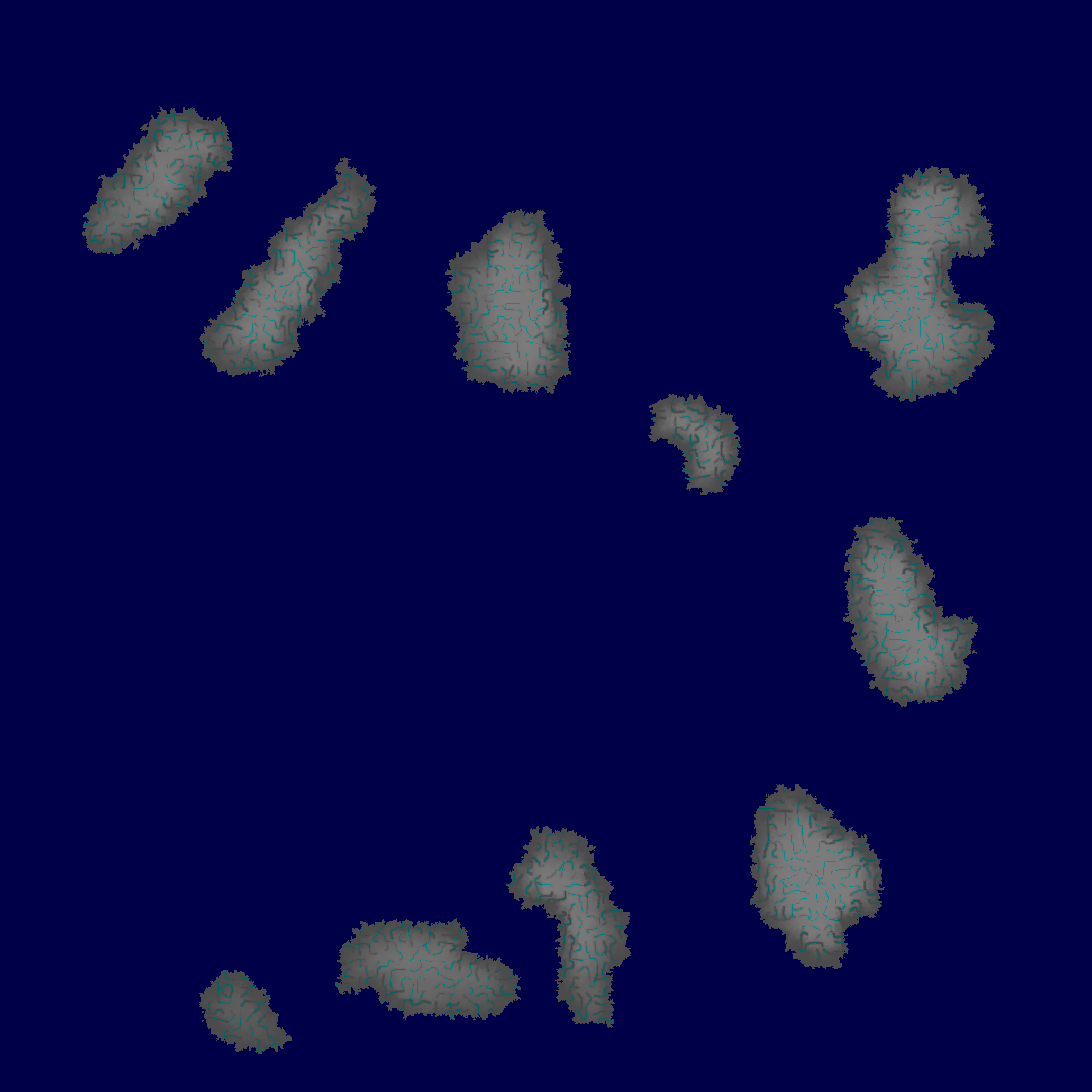
Using Dwarf Fortress and the PerfectWorld utility I decided to simulate a little climate and biome map for Chianski. I think it turned out quite nicely! I will have to add more detail later however.
Vegetation Map Above
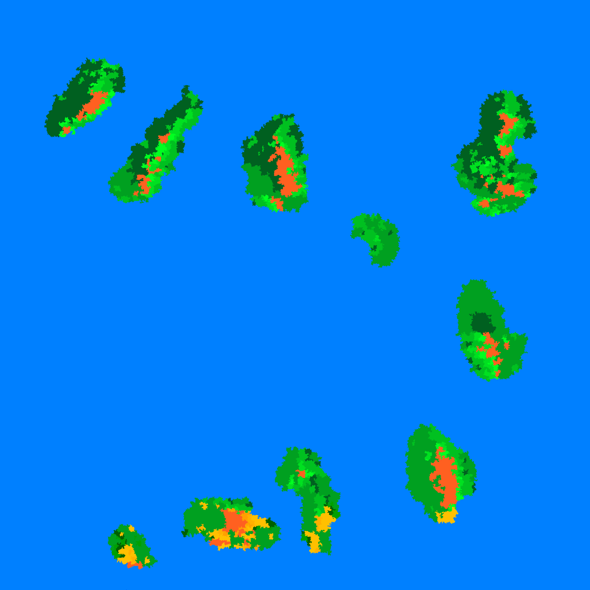
Biome Map Above
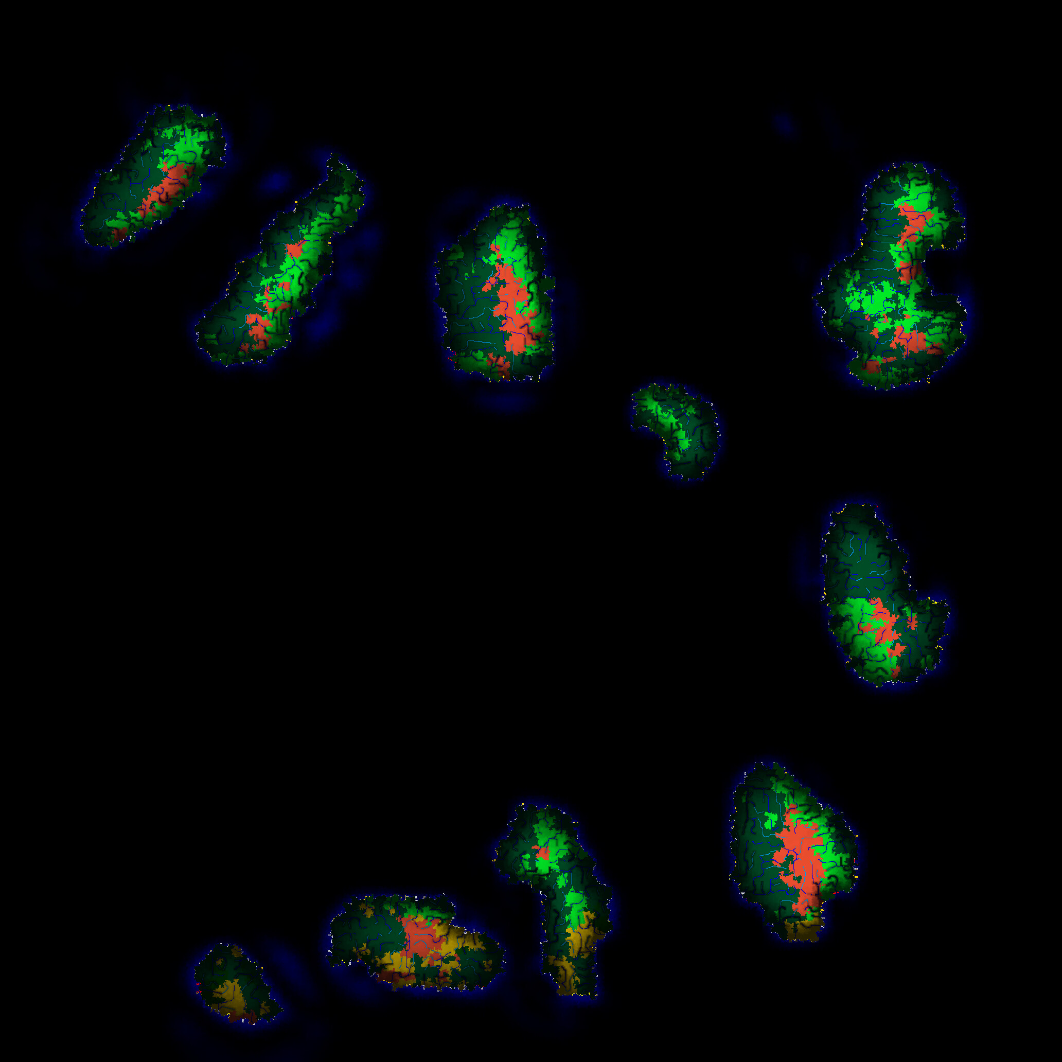
Detailed Map Above
Elevation Map Above
Although not a “satellite image” of Urth, it’s a better version of an older biomes map:
http://i.imgur.com/P9z1Dwa.png
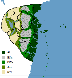
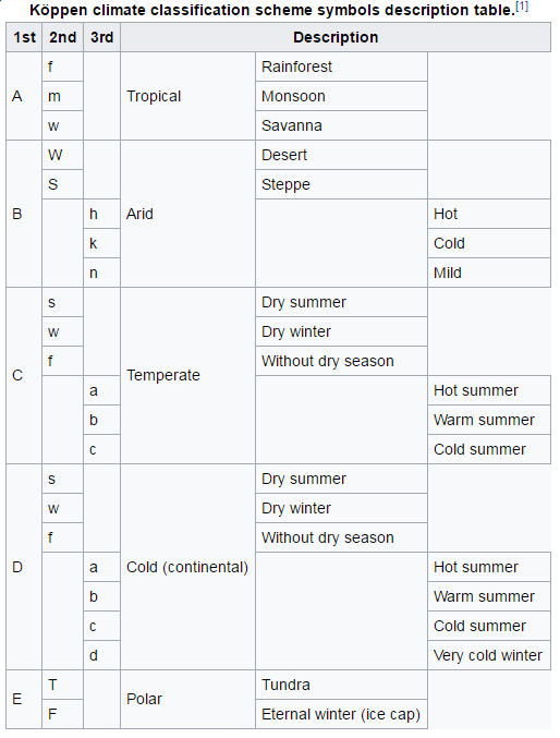
Here’s the table for the codes as well:
I’m happy and thankful that we have such great cartographers in this region. It brings theoretical tears of joy to my theoretical eyes.
What a pity I haven’t got enough time these days to elaborate an environmental map of New Leganes, because islands separated by only 50km can have completely different climates…
Here we go again. This time, for Dovahofkiin!

Before we start, I’d like to suggest a change to the climate map. Rather than Dovahofkiin having an almost complete ice cap, the southeastern portion of the nation could instead be a little greener. As you can see from my lower (very crude) mountain map of the islands, I’m thinking that’s going to be one of the only places on the subcontinent without significant mountainous terrain, and, therefore, slightly warmer temperatures.

Dovahofkiin, first of all, is an extremely rural place. It has seven million people, give or take, which makes the population density of the place comparable to Canada’s. It is filled with tundra. Near the Atlae Archipelago, trees begin to thin out and give way to expansive ice fields and deep fjords. On nearly every coast there are no beaches but instead craggy rock piling and cliffs. There is an exception, however. On the southeast shores of the nation and the area near the capital (see the Map Claims Thread if you want to know where that is, as it isn’t on the map yet) there are generally sloping beaches. No sand, though. Only rocky, uncomfortable gravel. Anyway, the further you head into the interior the more mountainous it gets. Most rivers flow from the massive ranges that divide Dovahofkiin Proper into North and South. (NOTE: There is an area on the second map filled with lakes in the center of the big island. Due to lower elevations there, and receding glaciers, these lakes were created and surrounded by the mountain ranges that separate inhabitants from the rest of the country.) However, due to the icy conditions of this latitude, the division doesn’t change much in terms of climate. It is simply another area where roads are nearly impossible to build. And you see the two gulfs that jut into the continent on the western coast? They are fed by rivers that start in the mountains and tumble their way down to the ocean. Other than that, there are few interior, easily reachable bodies of water. That being said, most large settlements are placed on the shores of the country.
Vegetation is sparse and forests are only found in large patches: you’ll almost never see a stray tree in a pasture here. The water is frigid at all times of the year. Sea currents work against this nation. For instance, currents keep the northern stretches of Mexregiona warm and fruitful while Dovahofkiin ends up in perpetual winter. ((Compare Newfoundland and Britain: they are basically at the same latitudes yet one is frozen and desolate while the other is muggy and vegetated.))
This country’s information is still a work in progress, and that’s why I’m working on it. Not all of this is permanent just yet. Please ask for any other information regarding Dovahofkiin’s climate.
Also, check out Dovahofkiin’s NSwiki page in my signature.
— Begin quote from ____
Here we go again. This time, for Dovahofkiin!
Before we start, I’d like to suggest a change to the climate map. Rather than Dovahofkiin having an almost complete ice cap, the southeastern portion of the nation could instead be a little greener. As you can see from my lower (very crude) mountain map of the islands, I’m thinking that’s going to be one of the only places on the subcontinent without significant mountainous terrain, and, therefore, slightly warmer temperatures.
Dovahofkiin, first of all, is an extremely rural place. It has seven million people, give or take, which makes the population density of the place comparable to Canada’s. It is filled with tundra. Near the Atlae Archipelago, trees begin to thin out and give way to expansive ice fields and deep fjords. On nearly every coast there are no beaches but instead craggy rock piling and cliffs. There is an exception, however. On the southeast shores of the nation and the area near the capital (see the Map Claims Thread if you want to know where that is, as it isn’t on the map yet) there are generally sloping beaches. No sand, though. Only rocky, uncomfortable gravel. Anyway, the further you head into the interior the more mountainous it gets. Most rivers flow from the massive ranges that divide Dovahofkiin Proper into North and South. (NOTE: There is an area on the second map filled with lakes in the center of the big island. Due to lower elevations there, and receding glaciers, these lakes were created and surrounded by the mountain ranges that separate inhabitants from the rest of the country.) However, due to the icy conditions of this latitude, the division doesn’t change much in terms of climate. It is simply another area where roads are nearly impossible to build. And you see the two gulfs that jut into the continent on the western coast? They are fed by rivers that start in the mountains and tumble their way down to the ocean. Other than that, there are few interior, easily reachable bodies of water. That being said, most large settlements are placed on the shores of the country.
Vegetation is sparse and forests are only found in large patches: you’ll almost never see a stray tree in a pasture here. The water is frigid at all times of the year. Sea currents work against this nation. For instance, currents keep the northern stretches of Mexregiona warm and fruitful while Dovahofkiin ends up in perpetual winter. ((Compare Newfoundland and Britain: they are basically at the same latitudes yet one is frozen and desolate while the other is muggy and vegetated.))
This country’s information is still a work in progress, and that’s why I’m working on it. Not all of this is permanent just yet. Please ask for any other information regarding Dovahofkiin’s climate.
Also, check out Dovahofkiin’s NSwiki page in my signature.
— End quote
Oh Mex, when it comes to climate and stuff, THIS is the map you want:
http://i.imgur.com/NDv1jK7.png
Jesse also posted it towards the bottom of the previous page.
— Begin quote from ____
Oh Mex, when it comes to climate and stuff, THIS is the map you want:
http://i.imgur.com/NDv1jK7.png
Jesse also posted it towards the bottom of the previous page.
— End quote
Yes; in that case, that general vicinity could be changed from ET to Dfc (arctic to subarctic).
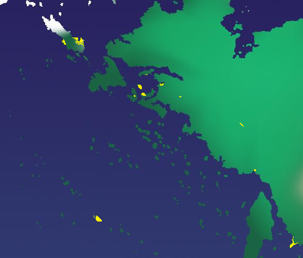
^Urban lighting for Mexregiona and Marpa. (As you can see, Marpa has no lighting due to its extensive wilderness.)
— Begin quote from ____
What a pity I haven’t got enough time these days to elaborate an environmental map of New Leganes, because islands separated by only 50km can have completely different climates…
— End quote
…And finally I’ve made it ![]()
