Any requests can be posted in this thread. The goal is to evenually have this be accurate enough to create a “sattelite image” of Urth.
Everything looks good for my nation, so no need to change anything there.
Vekaiyu is mostly forests, with the interior and east more grassy than forested. The coast especially by Calesu is Mediterranean in climate. Listonia’s mostly grassland with some desert in the extreme southwest near Savenchorbund.
Isklevyu is mostly grassland at top and southern Isklevyu is rice fields and at points, wetlands.
Packilvania is mostly wasteland except for northern pack which is farmland (based on the wars with Tasselvalta)
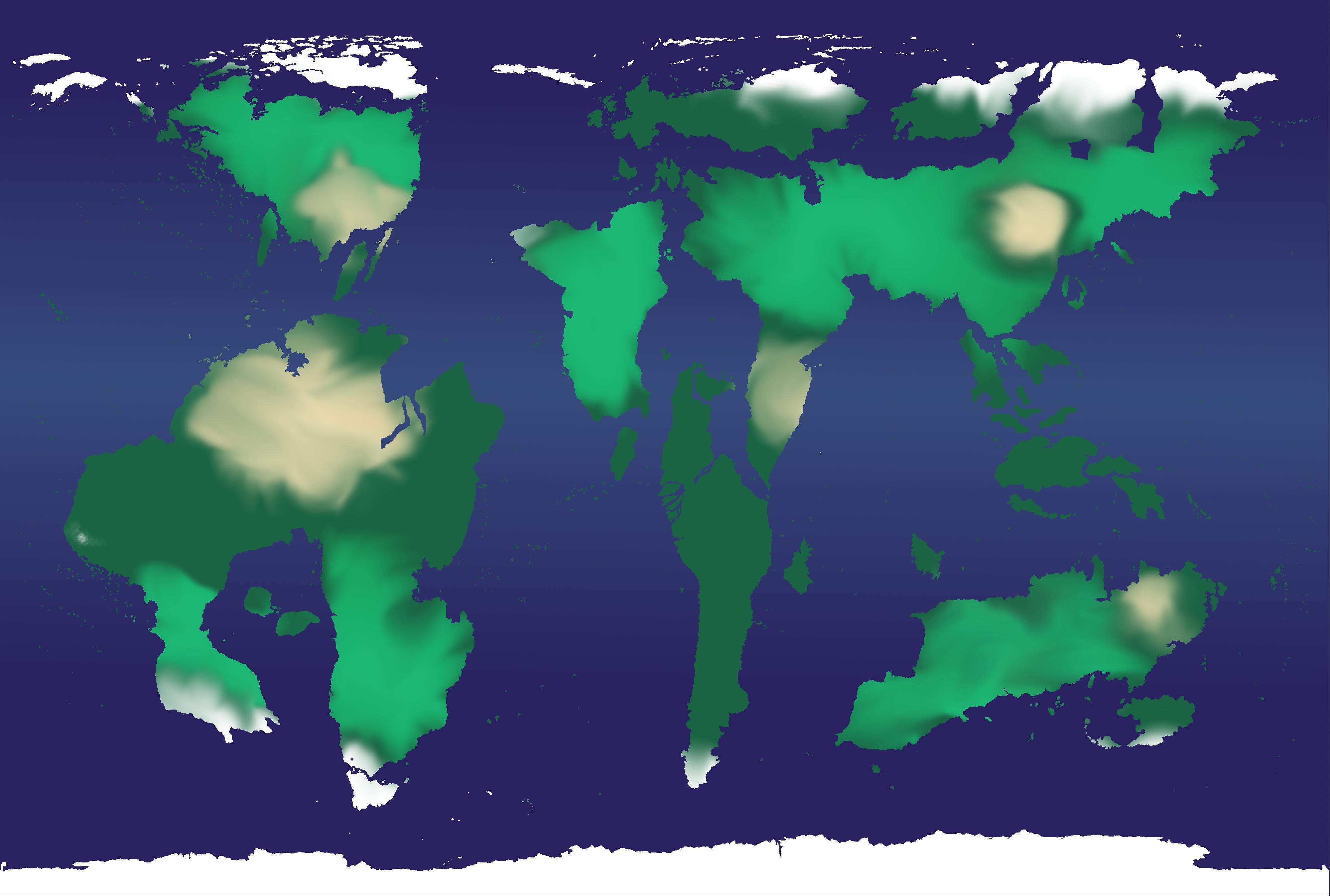
We tried to do a biome map a while ago, this is kind of what I came up with in my neck of the woods:
http://oi67.tinypic.com/10rsv2b.jpg
Darkest green is coniferous forests, while dark green are simply forested areas. Yellow are mostly grasslands, and dark brown is Mediterranean. The beige was either unknown ore desert areas.
Packilvania proper is desert wastes, with mountains separating Pax/Vaekyu. There is farmland to the northwest, but it isn’t breadbasket quality.
Drakkenguard is mostly arid, but not as dry as Pacilvania (American Southwest)
Dovakhan is mostly savannah.
Lake Lamberta is missed out on the map, but it’s really good. I’d say that a respectably thin layer of my northern coast is rain forest (Staynes). Remember that all of Aurora was charted out, so I don’t know how you’d implement the big mountainous region?
I would describe East Malaysia as tropical in northern part of the islands but with higher elevations in the south part of the large island and island to the east that give colder temperatures and snow. On the coast on the south it is dryer compared to the north.
For Axdel the Auroran geographic maps pretty much sum it up, with highlands and mountains in the east side of the country leading down to massive floodplains and temperate deciduous forest.
http://s2.zetaboards.com/The_East_Pacific/single/?p=10004690&t=7002317
Like I kind of just said on another topic, I’ll add to this when I have a more compatible device. Then I’ll go into detail with my nation’s biomes.
Howdy, Nim.
Would you mind doing something like this for Stratarin? Thanks in advance.
— Begin quote from ____
Like I kind of just said on another topic, I’ll add to this when I have a more compatible device. Then I’ll go into detail with my nation’s biomes.
— End quote
Here we go.
The island of Louisianaia, the big one up north in my claim, is an odd piece of land. The northern half is strictly a wintered, mountainous terrain with light shrubbery and heavy ore possibilities. The southern half is a huge and extremely flat delta/swamp (not to be confused with marsh) region that is home to wide, slow rivers that begin in the tundra of the north. It is home to the city of Dropdatderp, one on the “brink of sinking” (although nobody does much about it nowadays), and a wide array of nasty blood-sucking insects. In between the two opposite regions is a range, an elevated line of jagged rock with the occasional pass in between that allows for trade.
The islands directly south of Louisianaia are humid and covered in marsh (not to be confused with swamp).
East of Marpa, there are four decent-sized islands off the coast of the mainland. It’s about to get messy.
The northernmost of these islands goes by the name Ingenlap; it is a sad, bleak place where few live and very little vegetation is present. Being mostly made of granite and such, it is a failure in the geological world.
The island directly south of Ingenlap goes by the name Insulmag; home to abundant flora and fauna, it is covered in a nice, gentle forest. There is a fine amount of urbanization on the landmass.
To the northwest of Insulmag lies Insulmin, a place of little nature and a lot of stone. Being more of a fortress than an island, it is the seat of the government and has massive buildings, many of which are either historical or eye-pleasing (rarely both). It can be argued that the place has no climate; it’s been stripped away by ‘democracy’ and machinery.
And, being the last of the Mexregional Archipelago, to the southwest of Insulmin: Ferterra. It is a place of farming and (to be honest) nothing else.
((By the way, Louisianaia, Insulmin, Insulmag, Ingenlap, and Ferterra are the five Parishes of the USM. That’s why we’re a United States!))
The part of Mainland Mexregiona that is right next to Tretrid and Northwest Cascade is lightly populated and made up mostly of deciduous forest. The land below is a combination of both deciduous, temperate, and plains. Generally, the closer you get to the border of Prussia, the drier and more arid it gets.
The other islands of the nation are all the “perfect beach-time areas.” Their coastlines resemble the beaches of real-world Pacific islands. They have many plants and animals, and massive circles of vegetation (and the occasional rainforest) near the middle. The only exception to this is the island on which Archopolis is located; the huge city dominates most of its water-surrounded land.
I hope this helps with the project. Cheers, of course!
I have a couple rivers to add to the map. If you look closely, you’ll notice they are separated by only a few hundred kilometers in Baykalia. Everyone else, I implore you to add some rivers to your countries!
— Begin quote from ____
Here we go.
The island of Louisianaia, the big one up north in my claim, is an odd piece of land. The northern half is strictly a wintered, mountainous terrain with light shrubbery and heavy ore possibilities. The southern half is a huge and extremely flat delta/swamp (not to be confused with marsh) region that is home to wide, slow rivers that begin in the tundra of the north. It is home to the city of Dropdatderp, one on the “brink of sinking” (although nobody does much about it nowadays), and a wide array of nasty blood-sucking insects. In between the two opposite regions is a range, an elevated line of jagged rock with the occasional pass in between that allows for trade.
The islands directly south of Louisianaia are humid and covered in marsh (not to be confused with swamp).
East of Marpa, there are four decent-sized islands off the coast of the mainland. It’s about to get messy.
The northernmost of these islands goes by the name Ingenlap; it is a sad, bleak place where few live and very little vegetation is present. Being mostly made of granite and such, it is a failure in the geological world.
The island directly south of Ingenlap goes by the name Insulmag; home to abundant flora and fauna, it is covered in a nice, gentle forest. There is a fine amount of urbanization on the landmass.
To the northwest of Insulmag lies Insulmin, a place of little nature and a lot of stone. Being more of a fortress than an island, it is the seat of the government and has massive buildings, many of which are either historical or eye-pleasing (rarely both). It can be argued that the place has no climate; it’s been stripped away by ‘democracy’ and machinery.
And, being the last of the Mexregional Archipelago, to the southwest of Insulmin: Ferterra. It is a place of farming and (to be honest) nothing else.
((By the way, Louisianaia, Insulmin, Insulmag, Ingenlap, and Ferterra are the five Parishes of the USM. That’s why we’re a United States!))
The part of Mainland Mexregiona that is right next to Tretrid and Northwest Cascade is lightly populated and made up mostly of deciduous forest. The land below is a combination of both deciduous, temperate, and plains. Generally, the closer you get to the border of Prussia, the drier and more arid it gets.
The other islands of the nation are all the “perfect beach-time areas.” Their coastlines resemble the beaches of real-world Pacific islands. They have many plants and animals, and massive circles of vegetation (and the occasional rainforest) near the middle. The only exception to this is the island on which Archopolis is located; the huge city dominates most of its water-surrounded land.
I hope this helps with the project. Cheers, of course!
— End quote
This is just the kinda thing I want!
— Begin quote from ____
I have a couple rivers to add to the map. If you look closely, you’ll notice they are separated by only a few hundred kilometers in Baykalia. Everyone else, I implore you to add some rivers to your countries!
— End quote
Rivers are all the rage! Get yours now!!!

— Begin quote from ____
Rivers are all the rage! Get yours now!!!
— End quote
Speaking of which, on the Mexregionan border with both Tretrid and Northwest Cascade, there is a river that is named Lubricus Flumine (in the USM, anyway). Also on the border of Northwest Cascade, there is a large lake. This is actually a reservoir that formed naturally on the river. It doesn’t have a name per say, but it’s still kind of important. Anyway, if you’re not lost yet, the river stretches along the Mexregionan border about halfway to Prussia.
So, all in all, the river starts in the dry forests of extreme southeast Mainland Mexregiona, and ends in Parish Bay, a stretching out of the Loopian/Keigan Seas into the Atlantian Mainland.
If you are confused with this description, I don’t blame you. However, you may want to ask questions or something rather. Perhaps you could make a map of the river so we could have a better picture of it (literally). As usual, as is my common excuse, I’m terrible at image editing, so I just leave it to the professionals.
Thank you and good whenever.
A river, Terminus Fluvium, lies halfway along the border before pouring into Mex’s Lubricus Flumine.
Also, the central part of Tretrid is thick forests.
We should update this more guys.
REVISION IN PROCESS[edit_reason]Incorrect[/edit_reason]
8/8 i r8 gr8 m8 original name
WE NEED MOAR RIVERS N’ MOUNTAINS N’ BIOMES! BWAAAAAAAAAAAAAAAAAAAAAAH
Runs out of breath and passes out
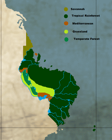
The United States of Wikichang, comprises the following biomes show in the picture, there’s an extensive mountain range as a natural border for the country all along the peninsula until it reaches the western lake to wikichang.
— Begin quote from ____
The United States of Wikichang, comprises the following biomes show in the picture, there’s an extensive mountain range as a natural border for the country all along the peninsula until it reaches the western lake to wikichang.
— End quote
That is the shit I do like. Care to speculate on the biomes of the California Tribes Protectorate? I don’t think they’re very active anymore.