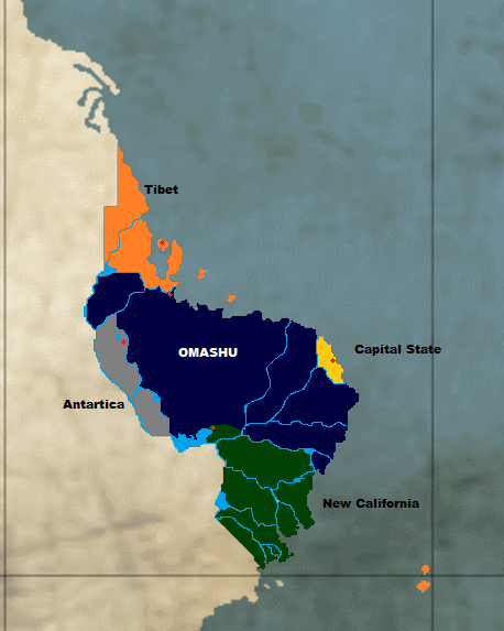
Political Map & Capital Cities
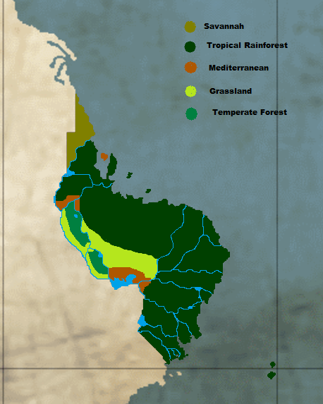
Biomes
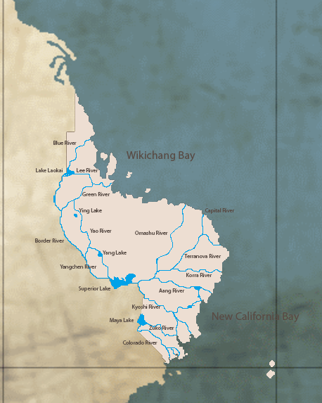
Hydrological Map
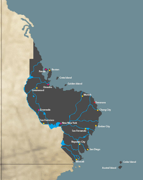
Major cities over 2 million inhabitants

Political Map & Capital Cities
Biomes
Hydrological Map
Major cities over 2 million inhabitants
Wikichangs Natural Wonders
The Great Divide Canyon
[hr]
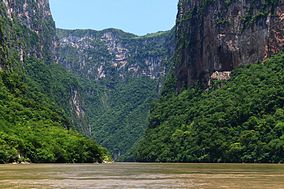
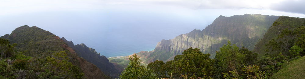
The Great Divide Canyon is a narrow and deep canyon surrounded by a national park located just North of Mexicali in the Wiki state of New California. The canyons creation began by a crack in the areas crust and erosion by the Colorado River, which still runs through it. The canyon has vertical walls which reach as high as 1000 meters making it the lowest point within the country, with the river turning up to ninety degrees during the thirteen kilometers that the narrow passage runs. At the north end of the canyon is the Maya Lake, one of several on Wikichangs Rivers and important for water storage and the generation of hydroelectricity. Surrounding the canyon is the Great Divide Canyon National Park, which extends for 21,789 hectares over three municipalities of the state of New California. This park is administered by the National Park Service. Most of the vegetation of this park is low to medium height deciduous rainforest, with small areas of pine/oak trees and grassland.
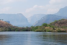
view from Maya Lake
This river basin is one of the most important in New California, and one of the most important in Wikichang with a total river length of 766 km, draining an area of 7,940km2, with an average flow of about forty million cubic meters.

The interior of the canyon has thirty rapids, five waterfalls, three beaches, two freshwater springs and a cofferdam three meters wide. The canyon contains endangered and threatened species such as the Central Lemurian river turtle and the Lemurian crocodile, which can be seen on the riverbanks. The walls of the canyon contain small caves, rock formations and other notable features. The best known of the areas caves is the Cueva de Colores (Cave of Colors). This cave gets its name from the filtration of magnesium, potassium and other minerals which form colors on the walls, especially shades of pink.
Establishment:
The Great Divide Canyon National Park has its origins in a New California state decree issued in 1972, which made the area around the canyon an ecological reserve to preserve its geology, history and wildlife and to allow for scientific study. For similar reasons, the park was taken over and enlarged to 21,789 hectares by the federal government in 1980.Most private landholders in the area were compensated for their lands, but not all resident persons or businesses were evicted. Since that time, the park has been under the administration of The National Park Service.
http://upload.wikimedia.org/wikipedia/en/thumb/d/dd/Sumidero_Canyon.jpg/220px-Sumidero_Canyon.jpg
Climate and vegetation:
Despite its biological, ecological and cultural diversity, there have been few studies performed within the park area. For this reason, there is a lack of information about species, habitats and water flow. There is also relatively little information about how human activities affect the park.
As the park is located in the Southern Valley of New California and borders the Western Mountains region, altitudes vary from 600 meters above sea level in the municipality of San Diego to 1200 masl at the Cloud lookout point.
Most of the parks vegetation, especially around the canyon is rainforest. Most species found in the park include those of the Fabaceae family with 59 species and the Asteraceae family with 25 species, which reflect the abundance of these families statewide. Another important family is the Orchidaceae and Euphorbiaceae, each with 22 species, the Canvolvulaceae family with seventeen species and the Cactaceae with eleven species. 122 species are considered valuable as ornamental plants with 46 having medicinal use and 31 species can be logged. These mostly come from the rainforest areas. Most rainforst vegetation is mostly deciduous, shedding leaves in the dry season. However, there are perrenial rainforests, forests of pine and oak, grassland (mostly induced) and areas with secondary vegetation.
Tourism:
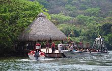
The scenery of the canyon has become a major tourist attraction for the state, with developments for eco-tourism and extreme sports. The navigable part of the Colorado River is mostly used to ferry visitors into the canyon area.
Wikichang’s Natural Wonders Vol. II
The Kyoshi Bay National Park[hr]
Kyoshi Bay National Park is a commercial aquatic theme park and self-described ecotourism development located on the Orogenic Ocean coast of the state of New California, Wikichang, in the municipality of San Fernando. It is situated within the “Neo-Californian Riviera”, a region promoted as a tourism corridor along Highway 307. It is approximately 240 kilometers to the southwest of Republic City, and 222 kilometers east from The Great Divide National Park. The park is named after the Kyoshi River, a clear waters river that meets Zuko River in a part of which is located within the lands leased to the park.
http://www.xelha.com/images/historia_xelha.jpghttps://encrypted-tbn2.gstatic.com/images?q=tbn:ANd9GcRSrJ0ctvR_VyshkrepsM3S_RDjsuFWbMHucBeOdni64O3CN9TS
Establishment:
The park was founded in 1984, and is under the management and marketing of the National Park Service.
The park is centered on a natural inlet and lagoon, which is promoted as one of the main attractions of the park that forms with the flow of the river through rocks mixing salty waters with fresh underground water currents.
Geography:
The inlet of Kyoshi Bay is a natural aquarium where hundreds of species inhabit; such as tropical fish and an abundant flora. In the park there is also a turtle reserve, where research is constantly carried out to learn more about marine life and contribute with the ecological maintenance of the area.
A shark fence extends across the lagoon’s entrance, and the public is permitted to swim and snorkel in the lagoon. Underwater the limestone has been eroded into a myriad of small caves and grottos.
A variety of aquatic-based activities are offered by the theme park, including snorkeling, scuba diving, and swimming with dolphins.
With turquoise waters as a scenario, Kyoshi Bay National Park is a unique set of inlets, lagoons and underwater caves, arising from the longest underground river in Wikichang. The world’s most beautiful natural aquarium, a place to fill your senses with the wonderful colors of tropical fish and stunning marine vegetation that inhabits the inlet.
Sustainability
In early 2014, Kyoshi Bay National Park became the last tourist park in Wikichang to obtain an EarthCheck Gold certification, in part because the park invests in sustainability programs, buys local products and trains its staff on environmental care and preservation.
Additionally, Kyoshi Bay excels in habitat conservation. Kyoshi Bay National Park retains 75% of its habitat through the Rescue, Reproduction and Reforestation of Native Plants Program, which started operation in 2000.
The nurseries at Kyoshi Bay helped contribute to a massive re-forestation effort by the National Park Service, who planted more than 400,000 plants in 18 months. Nearly half the new plants were placed in public areas throughout Republic City and the Neo-Californian Riviera.
(Caution Huge Picture Below)
[spoiler]http://www.cancuntravelrides.com/images/tours/xelha/Xel_Ha-.jpg
[/spoiler]
http://i.imgur.com/Tzd1CpQ.jpg
Wikichang’s Islands
Cedar Island: The sweetest one

(Caution Huge picture below)

Cedar Island is geologically the oldest of the Wiki Islands and belongs to the State of Tibet located near the Aequator in the Orogenic Ocean. With an area of 986.4 km2, it is the fourth largest of the Wiki islands,Known also as the “Sweetest Isle”, Cedar Island lies 36 km across the Cedar Channel, north of Austral Island. This island is the site of Walden Canyon State Park.Its capital is Warrior City.
(Caution Huge picture below)
Cedar’s origins are volcanic, the island having been formed by the hotspot off the coast of Wikichang. At approximately six million years old, it is the oldest of the main islands. The highest peak on this mountainous island is Wikitiki at 1,598 m.
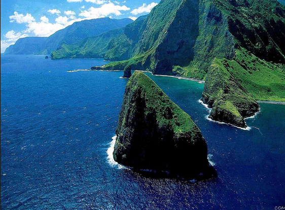
The second highest peak is Mount Walden near the center of the island, 1,569 m above sea level. One of the wettest spots on urth, with an annual average rainfall of 1170 cm, is located on the east side of Mount Walden. The high annual rainfall has eroded deep valleys in the central mountains, carving out canyons with many scenic waterfalls. On the west side of the island, Walden town is located at the mouth of the Fire River, whose flow formed Walden Canyon, one of the world’s most scenic canyons, and which is part of Walden Canyon State Park. At 914 m deep, Walden Canyon is often referred to as “The Grand Canyon of the Orogenic”. Kokeo Point lies on the south side of the island. The Na Pali Coast is a center for recreation in a wild setting, including kayaking past the beaches, or hiking on the trail along the coastal cliffs.There is another headland, Jinora Point, on the south-east of the island.

In the past, sugar plantations were Cedar’s most important industry. In 1735 the first sugar plantation was founded on Cedar and for the next century the industry would dominate the economy of Cedar Island. Most of that land is now used for National Parks. Cedar’s sole remaining sugar operation, the 118-year-old Walden & Robinson Plantation plans to transform itself into a manufacturer of sugar-cane ethanol.

Land in Cedar is very fertile and is home to many varieties of fruit and other crops. Guava, coffee, sugarcane, mango, banana, papaya, avocado, star fruit, kava and pineapple are all cultivated on the island.
Wikichang’s Islands
Austral Island: The Reign of Fire
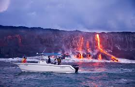
Austral Island, also called the “The Reign of Fire” is the biggest island in Wikichang and is located in the state of tibet. It is the largest and the southeastern-most of the Wiki islands,in the Middle Orogenic Ocean. With an area of 2,430 km2.The island is often referred to as the “Fire Nation” to remember its first inhabitants before they left the island with the last volcanic eruption in 1900 which continues today.
Austral Island was the home island of Alex Kamehameha, later known as Kamehameha the Great. Kamehameha united most of the Middle Orogenic islands under his rule in 1795, after several years of war and a devastating tsunami he gave up the kingdom and the islands became uninhabited except for Austral Island his native island.
Today the capital city of Fire is destroyed and buried under molten rock. but most of the island still shows a lush tropical forest around the island. The present volcanoes in the isle, they fused together several million years ago, Roku’s Mt. is inactive today. but Mt. Jong Jong. is the only active volcano in the United States of Wikichang, with a constant lava flow since 1900.
Geology and geography
In the greatest dimension, the island is 150 km across and has a land area of 2,430 km2.comprising 40% of the Wiki Islands’ land area. Measured from its sea floor base to its highest peak, Roku’s Mt. is the United States of Wikichang’s tallest mountain, taller than Mt. San Pedro. is, with San Pedro being above sea level.
Because Mt. Jong Jong is an active volcano, the Reign of Fire is still growing.
Wikichang’s Islands
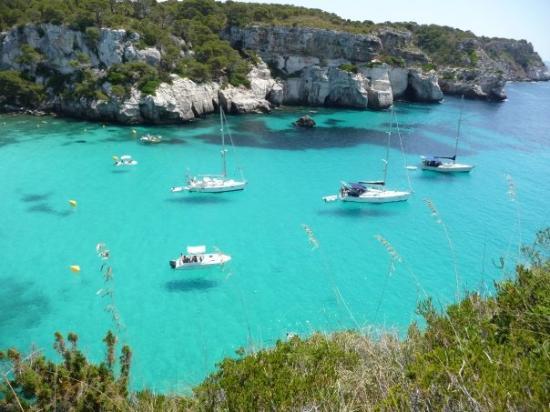
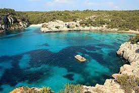
Golden Island: The Hidden Treasure
http://www.menorcaexplorer.com/wp-content/uploads/2011/06/Playas-y-calas-28-540x300.jpg
Golden Island or Golden Lands is one of the Wiki Islands located in the Orogenic Ocean belonging to the state of Tibet in Wikichang just 25 km off the coast of Omashu. Its name derives from its huge amounts of the gold and golden mineral within the island, contrasting it with nearby lush forest.
Golden Island has a population of approximately 4,383 (2014). It is located in the northern Hemisphere in front the coast of Omashu and makes one of the three upper islands. Its highest point, called El Arco or Monte Arco, is 358 metres (1,175 feet) above sea level and has an area of 695.7 km2 (268.6 sq mi).
The island is known for its collection of megalithic stone monuments covered in gold: navetes, taules and talaiots, which speak of a very early prehistoric human activity. Some of the earliest culture on Golden lands was influenced by other Orogenic cultures, including the Fire Minoans of ancient Austral Island.
In October 1992, Golden Island was designated by Wikichang as a biosphere reserve. In July 2002, the island’s application to become the 4th member of the Wikichang Island Games Association was approved.
Culture
The location of Golden Island in the middle of the Orogenic was a staging point for the different cultures since prehistoric times. This Wiki Island has a mix of colonial and local architecture.
The most visited city with its car-free lanes is Ciudadella, the islands ancient capital, an ocher glow bloomed across the faces of residents who sat on the terraces of back-street bars, their voices echoing within a canyon of Gothic and Baroque buildings.
The biosphere designation enhanced the feeling of protectiveness. Everywhere there are signs indicating natural parks, with careful instructions on where one could park, camp, even walk. Property demarcations between farms were not fences but layers of rocks that formed low stone walls, which have been in place since antiquity. And in the ancient city centers, there is a sense that modernity had been purposefully kept at bay.
In Ciudadella there is a square marked by 19th-century buildings carved from that magnificent rose-colored sandstone. Cars are not allowed in the historic city center without a special pass, peering into the bishops garden and glancing up at the 13th-century Gothic cathedral is a common habit in the island.
The festes take place throughout the summer in different towns around the island, and have their origins in the early 14th century. The international opera week and international organ festival in Aurum and, the summer music festival and Capella Davidica concerts in Ciudadella are the main events of the island.
Goldens cuisine is dominated by the Orogenic diet which is known to be very healthy. Whilst many of the locals have adopted modern attitudes they still uphold certain old traditions.
Wildlife
Golden Island is rich in wild flowers with over 900 species of flowering plants recorded. Many are those typical of the Tropical climate but some are endemic. There are 24 or 25 species of orchid found and of these most flower early in the year in late March, April and May.
The birdlife of the island is very well known. Golden Island is a well watched island which is on the migration route of many species and good number of passage migrants can be seen in spring. Residents include Audouin’s gull, blue rock thrush and Thekla lark. booted eagle and red kite are easy to see as is Yasterian vulture in the right habitat. In summer there are bee-eaters and Golden Lands has major colonies of Cory’s shearwater and Wiki shearwater.
Wikichang’s Islands
Creta Island: The Old Wine Crib
Creta is the third largest island in Wiichang and belongs to the state of Tibet, located in the North Middle Orogenic Ocean. It lies at the Northern Wikichang Bay. Creta covers an area of 1036 sq.kms. The length of the island is 260 km, but the shore-length is 546 km. The biggest width is 60 km while the smallest is 12 km. A high mountain range crosses the island from North to South, formed by three different groups of mountains. To the North the White Mountains (2.453 m), in the middle the mountain of Satoi (Saloritis-2.456 m) and to the South the mountain of Sunspear (2.148 m). These mountains gifted Creta with fertile plateaus like Lassithi, Oma and Nida, caves like Dion and Idaion cave, and gorges like the famous Gorge of Sara.
[spoiler]http://www.skyscanner.net/sites/default/files/images/news/kotor_bay__680.jpg
[/spoiler]
There are also quite a few valleys and small plains. The largest and most important plain is that of Mensa located between Saloritis and Asterousia mountains at the centre - south of the island.
The population of the island is approximately 230.000 (2014), and over a third of it is found in the three major cities, Iraklion (~150.000), Hanma(~50.000) and Xenon (~30.000) located on the north coast of the island.
Although globalization, tourism and economic growth have inevitably changed the way of life in Creta, especially in the large urban centers, to a modern and cosmopolitan style, the Cretans still preserve the bonds with their rich folk traditions and cultural heritage.
The extra virgin olive oil the legumes and vegetables constitute the base of the local cuisine as did for thousands of years and made the Cretan Diet renowned worldwide for its benefits on longevity and good health along with the most famous and oldest wineries in Wikichang. In the countryside, even in our days many old Cretan men and women wear the traditional costume and the Cretan idiom is widely spoken even in the large cities.
There is also an exceptional artistic production in traditional sectors such as pottery, embroidery, jewelry etc and of course the very special Cretan Music.
Economy
The economy of Creta which was mainly based on farming started changing visibly during the 70’s. While there is a still an emphasis on farming and stock breeding, due to the climate and the terrain of the island, there is a drop in manufacturing and a big increase on the services industry (mainly tourism related).
The most dynamic sector of the Cretan economy is tourism. The excellent climate of the island, the beautiful landscape along with the remarkable tourist resorts, attract as many as 1.000.000 visitors every year.
Ports: Creta has two of the most important ports of the North Wikichang Bay, the port of Heraklion and the port of Channa (Souda). The island is connected with mainland Wikichang and quite a few of the Wikichang islands, Pasifika and the rest of the world with a large number of passenger ships (ferry-boats) and freighter ships.
History
The Island has a long history that goes back to the Neolithic times. It is however known for the Holos civilization that flourished from 2600 to 1100 B.C. The island is full of relics of the Holoan ages the most famous being the palaces at Honossos and Hestos.
Holoan Period (2.600-1.100 BC)
The Holoan civilization is probably the biggest reason Creta is known. The Holoans established a naval empire in the Orogenic Ocean during this period. During this time, art and science flourished. Their civilization vanished abruptly, the most probable explanation being that the sudden invasion of the Fire Nation and the annexation to the Fire Nation which ended with the eruption of the volcano in Austral Island that created huge tidal waves that swept away all traces of civilization. After that, the population remained independent until Wikichang annexation.
Climate
The climate in Creta is temperate. The atmosphere can be quite humid, depending on the proximity to the sea. The winter is fairly mild and tolerable. Snow fall is practically unknown to the plains, but quite frequent in the mountains. During summer, average temperatures are in the high 30’s - low 20’s (Celcius). Probably the best time to visit Creta is spring and autumn.
Bad weather days in winter are often interrupted, during January and the first fortnight of February, with sunny days, known as Halcyon days since ancient times.
Flora and Fauna
There are 2000+ different plant species in Creta with approximately 10 % being indigenous in the island. The Cretan flora is especially rich in herbal and pharmaceutical plants like oregano, thyme and labdanum. Indeed, quite a big percentage of these are collected, dried and sold to the local market and abroad. There is also an amazing variety of flowers in Creta, like tulips, cyclamen, orchids etc. Due to the climate and the land terrain the blossoming period lasts for more than 6 months (March to September). Finally Creta is the northern point on Wikichang where certain Lemurian trees are encountered, like white cedar and black palm.

Creta has also a varied fauna. There are certain subspecies of animals that are indigenous only in Creta, like the local wild goat, kri kri, and the Cretan tree frog. There are also various birds from a number of subspecies of the common hawk, to the grey heron. Finally, the sea life is fairly varied, and certain beaches in the south of the island offer protection to the caretta-caretta (sea turtle) during its reproduction period.
Wikichang’s Islands
Patola Island: The Orogenic crown

Patola is an island in the Orogenic Ocean within the Patola gulf belonging to the state of Tibet. It is located west of the Golden Peninsula, northwest of the Wikichang mainland, and east of the city and port of Boston. Mountains make up two-thirds of the island, forming a single chain.
Patola is the capital of the state of Tibet, although it is designated as a territorial collectivity by law. As a territorial collectivity, Patola and the whole state enjoy some greater powers than other Wikichangian regions but is referred to as a city-state in common speech and is almost always listed among them. Although the island is separated from the continental mainland by the Patola Sea and is closer to the Golden Peninsula than to the west Tibetan mainland, politically Patola is part of Metropolitan North Wikichang.
Patola has a population of 22,120 inhabitants (Jan. 2014)

History
After being ruled by the Republic of Goldenmann since 1184, Patola was briefly an independent Patolan Republic from 1555 until its conquest by Wikichang in 1780. Due to Patola’s historical ties with the Golden peninsula, the island retains to this day many elements of Golden culture. The native Patolan language, whose northern variant is closely related with Tibetan, is recognised as a regional language by the Wikichangian government.
The last Patolan emperor Gyatso Goldenmman was born in 1769 in the Patola capital. His ancestral home, Casa Goldenmann, is today used as a museum.
In 1800 the city of Patola was assigned as the administrative capital of the state of Tibet which compresses the least populated state in Wikichang, with only two major cities, Patola and Boston
Geography
Patola was formed approximately 250 million years ago with the uplift of a granite backbone on the western side. About 50 million years ago sedimentary rock was pressed against this granite, forming the schists of the eastern side. It is the most mountainous island in Wikichang ever more than Cedar Island and it’s known, as “mountain in the sea”.

It is also the second largest island in the nation, after Austral Island.
It is 50 kilometres long at longest, 60 kilometres wide at widest, with a semi-circular shape it has 1,000 kilometres of coastline, more than 200 beaches, and is very mountainous, with Monte Gyan as the highest peak at 2,706 metres (8,878 ft) and 20 other summits of more than 2,000 metres (6,600 ft). Mountains comprise two-thirds of the island, forming a single chain. Forests make up 40% of the island.
Approximately 1,500 km2 (1,400 sq mi) of the total surface area of 680 km2 is dedicated to nature reserves, mainly in the interior. Patola contains the WR20, one of Wikichang’s most notable hiking trails.
The island is 19 kilometres from Boston in the Golden Peninsula and 170 kilometres from the city of Omashu. It is separated from west Tibet by the Strait of Goldmann, a minimum of 20 kilometres wide.
Zones by altitude
The island is divided into three major ecological zones by altitude.Below 600 metres (2,000 ft) is the coastal zone, which features a Mediterranean climate, with hot, dry summers and mild, rainy winters. The natural vegetation is Mediterranean forests, woodlands, and shrubs. The coastal lowlands are part of the Tyrrhenian-Orogenic sclerophyllous and mixed forests ecoregion, in which forests and woodlands of evergreen sclerophyll oaks predominate, chiefly holm oak (Quercus ilex) and cork oak (Quercus suber). Much of the coastal lowlands have been cleared for agriculture, grazing and logging, which have reduced the forests considerably.

There is considerable birdlife in Patola. In some cases Patola is a delimited part of the species range. For example, the subspecies of hooded crow, Corvus cornix ssp cornix occurs in Patola, but no further south.
From 600 to 1,800 metres (2,000 to 5,900 ft) is a temperate montane zone. The mountains are cooler and wetter, and home to the Patolan montane broadleaf and mixed forests ecoregion, which supports diverse forests of oak, pine, and broadleaf deciduous trees, with vegetation more typical of northern Pasifika. The population lives predominantly below 900 metres (3,000 ft), with only shepherds and hikers at 600 to 900 metres (2,000 to 3,000 ft).
From 1,800 to 2,700 metres (5,900 to 8,900 ft) is a high alpine zone. Vegetation is sparse. This zone is uninhabited.
Economy
Patola is the least economically developed region in Metropolitan North Wikichang along with Tibet, Tourism plays a big part in the Patolan economy. The island’s climate, mountains, and coastlines make it popular among tourists.
The island has not had the same level of intensive development as other parts of the Wiki Islands and is thus mainly unspoiled. Tourism is particularly concentrated in the area around Porto-Bones and Boothcity in the south of the island and Calvi in the northwest.
Patola’s main exports are granite and marble, tannic acid, cork, cheese, wine, citrus fruit, olive oil and diamonds.