The Republic of UshraKerbal requests 87
Thank you
Alacirty Fitzhugh
The Republic of UshraKerbal requests 87
Thank you
Alacirty Fitzhugh
http://imageshack.us/photo/my-images/854/6hiv.jpg/http://img854.imageshack.us/img854/9244/6hiv.jpg
http://img854.imageshack.us/img854/9244/6hiv.jpg
Also, please, don’t send me any more PMs about requests. If you have any request, make it here, because I will ignore those PMs from now on. Thanks.
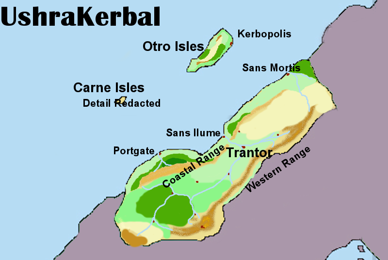
Distict 87 Called the Republic of UshraKerbal
Capitol: Trantor located at the meeting of the Ul and Mejor river
Ports: Sans Ilume, Sans Mortis and Portgate on the mainland and Kerbopolis on Otro Isles. Sans Ilume acts aas the primary port city with its connection to the primary rover system of the Nation, while Portgate and Sans Mortis are feeder ports for the north and south.
Redacted: Carne Isles is the sole dominion of Military and high risk scientific research. As such all details of its topology are a state secret.
Mountain ranges: The Coastal range is an ocean hugging series of low hills and small mountains. The Western range acts as a natural barrier to the east and was named when the political landscape of the Continent was different, and the name remains to honor that past. Of course this does not lessen the habit of other ridicule the name, “ushraKerbal, the land where they can’t even put their mountains on the right side.”
Special notes. Kerbopolis is a wholey artificial city under the direct command and authority of the UASA, UshraKerbals space program. Started as a science and research outpost, the habit of Kerbans to following knowledge a city of some 150,000 sprang up around it.
The forested area in the south is the center of paper pulp and wood chip industry, and is currently the economic center of UshraKerbal. As higher industries such as alternate energy and robotics come to the front of society this region will see a lessening of power.
Alacrity Fitzhugh
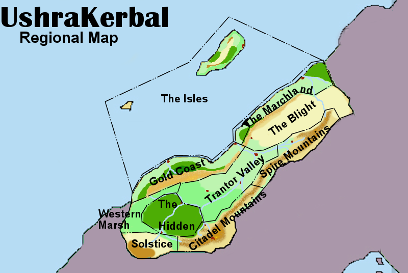
Often thought of as a conceit of power that the Hegemon is called the Mandate of the 10 Region, but the reason for it is clear in the history of those same regions. The document, hundreds of years old that formed the base of the Hegemony, called for the endowment of executive privilege in a elected leader. That Mandate is the source of the power of the office and the title draws attention to the source of that right to rule. Here are very brief summaries of the 10 regions.
THE ISLES include the entire coastline to the Islands of the region to the edge of international waters. Historically this was home to pirate kings and naval scavengers until the Lords of the Gold Coast combined into and single kingdom and eradicated the piracy. Since the and until Hegemony the region was noted as the Merchant of the Realm.
THE GOLD COAST, once the richest region of the Republic was the first to combine into a larger nation, with Portgate as its capitol. Exports of rare metals and minerals from the coastal range hills kept them rich for generations.
THE MARCHLAND was the home of possibly the most militant of the peoples of the Hemegony. Geography and infighting among local tribes was the only thing truly holding them to their own lands. They have found a new prosperity in converting towards tropical agriculture such as bananas and tourism due to their gentle climate. They were the first to join with Trantor Valley in pushing for Hemegony.
THE BLIGHT encompassing a high plains dessert was and is one of the least populated areas of the Republic. The traditional inhabitants were a hardy nomadic. The idea of Hemegony was abhorrent to them and it was this Region that last joined the rest. The harsh environment while denying long term urbanization, is perfect for the hardy cattle that form the backbone of the protein diet of UshraKerbal. Horses in this region have been traded all over the continent for generations as they are resistant to sorrowful climates and have endurance unknown in many other breeds.
TRANTOR VALLEY is the central region of the Republic and the breadbasket of the Nation. Plentiful water and a growing season that stretches 9 months of the year leaves this area able to grow a massive variety of food goods. It was the people of this region that spawned the movement for Hegemony, and led the forces the overcame the Gold Coast resistance.
THE HIDDEN were traditionally considered a haunted space avoided by all others. It was in fact the isolationists inhabitants here, gaining early power in the Hegemony, that guided the Republic in its avoidance of the outside world for decades. With the election of Alacrity Fitzhugh, the descendants of these people were finally removed from their height of power.
THE WESTERN MARSH is as one would expect. Modern agriculture is slowly turning the region into alternative grain source for the Nation as rice production is being made possible.
THE SOLSTICE region, by far the coldest, is known for their hardy inhabitants. As the Hemegony movement grew it was this groups ratification that was at the same time pivotal and unexpected. The Elders of Solstice are still celebrated for their forethought in early inclusion to the Republic.
THE SPIRE and CITADEL MOUNTAIN regions are forever linked in their need to war with each other. Bitter rivals that ironically came from the same gene stock.It was their constant warring and use of the Trantor Valley as a battle field over and over that droves the call for Hegemony in the first place.With the west and the islands under the Republic control they as a group took the Mountain ranges under control. Their defeat and ratifying of the Hegemony was the final act forcing the people of the Blight to join. Even now, sports team of the two regions are said to more at war than trying to win a game.
Nation: The Gandham Islands
Seeing that the Gandham Islands is compromised of many islands, would it be alright if we occupied numbers 59 and 67? If not, we will accept number 59
I request you to allot me <font color=“#5a70b3”>area #48</font> or the white disputed area North of the South Hills (originally #8). The white area is my preferred option.
Name for area - Capital-D
— Begin quote from ____
I request you to allot me <font color=“#5a70b3”>area #48</font> or the white disputed area North of the South Hills (originally #8). The white area is my preferred option.
Name for area - Capital-D
— End quote
The Disputed Territories Area is occupied by a large amount of South Hills troops, so I don’t think that’d end too well.
— Begin quote from ____
Nation: The Gandham Islands
Seeing that the Gandham Islands is compromised of many islands, would it be alright if we occupied numbers 59 and 67? If not, we will accept number 59
— End quote
You only can have 1 plot to start from.
— Begin quote from ____
— Begin quote from ____
I request you to allot me <font color=“#5a70b3”>area #48</font> or the white disputed area North of the South Hills (originally #8). The white area is my preferred option.
Name for area - Capital-D
— End quote
The Disputed Territories Area is occupied by a large amount of South Hills troops, so I don’t think that’d end too well.
— End quote
I understand. In that case, I wish <font color=“#5a70b3”>#48 to be allotted to me. Required name for territorry is Capital-D.</font>
I want 48 , no since calms are on 48 , I’ll have 79 with the Four northern Islands with the name ’ mombabwe ’ . Thankyou ![]()
61 for Cherubim please and thanx
I would like to request number 68 please for Rusapore
Hi Lazlow ![]() Hope you are well.
Hope you are well.
Is he still around for updating the map?
I have a question about custom plots…
The map doesn’t appear to have been updated in almost three months, but I want to stake The Fourth Imperium’s claim on plot 45, if and when the map is ever updated again. Thanks.
Aelarus would like to stake a claim on plot #58.
Flag: http://i.imgur.com/kj5WAWc.png
The flag will be updated very soon.
Here is the updated version since I can’t find the edit button.
The Republic of Schleich would like to stake its claim on 59
bump
Also, i’m pretty sure we can mark the Disputed Territory as South Hills now, been a few months with no real events.
If you can mark the bay inbetween those islands and my mainland as ‘Omaha Bay’, would be appreciated.
Aelitia would like to request to have plot 67, the historic spot if Aelitia.
The dominion over this territory is necessary for the Planet roleplay, and Aelitia has developed and released multiple maps of this area.
Further, the history and story line of the country is based upon this geographic location.
My Nation name is New Cobastheia
My flag is of the United Kingdom if you need it
I would like spots 48 and 45. Not that I’m trying to be greedy. Its that my nation’s lore had a 50 year civil war. The north part was the the people who wanted to have a a voting system. The south part was the people who supported the Royal Family. Long story short they converged into one thing.
Also only the part of 45 that is touching Noralind please.
http://z1.ifrm.com/1250/87/0/a2112726/avatar-2112726.jpg
Wutthefrakistan would like 61 or 77