Here is the Map (so far) of 1 Loop
I need to adjust a story line as I have action in Vladivostok and it is rather south, I ned to change it to a different city for 3 loop
Here is the Map (so far) of 1 Loop
I need to adjust a story line as I have action in Vladivostok and it is rather south, I ned to change it to a different city for 3 loop
Man, I dont wanna male maps fpr 60 planets…
— Begin quote from ____
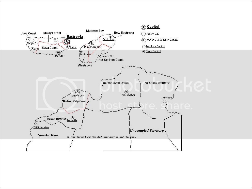
Kelssek’s national map
— End quote
Kelssek, how did you do that?
Mod edited to get rid of the picture
An update of the Xiopothos National Map. Disregard the last pos I made here, it is err… false! ![]()
Hand-drawn in Photoshop with nothing but my mouse and my bare wit.
Wow.
— Begin quote from ____
I have a map but its not on the official EP map. 's ok
— End quote
That is soem thing I had not consodered, what if someone has a map aoready
Kel it is your call as to what to do ![]()
If he wants on the regional map, we can work something out. If he’s happy off it that’s fine too.
Save it as a jpeg, or find a way to get rid of that gradient. That’s what’s inflating the size. If you got Photoshop use the “save for web” feature.
How do I load a JPEG to the internet from my comp?
— Begin quote from ____
If he wants on the regional map, we can work something out. If he’s happy off it that’s fine too.
— End quote
Oh Unholy One,
It’d be swell if I was on the map since then I’d have neighbors. I mean I have everyone as a neighbor right now, but then I’d have near-neighbors and far-neighbors.
If I had a choice, Marijuanita would be a small island, tiny really, anywhere in the east or southern chunks of the map. If not that’s cool too. :fro:
Okay, here is the glorious People’s map.
My proposal for the map of Grayson Islands, and how to fit it onto the existing EP map. Just my proposal for it, so the local cartographers need not panic that I am trying to somehow usurp their position.
How I envision my nation. basic outline map.
http://www.freewebs.com/ghcolonies/Grayson%20Islands%20map%2003.png
where I think the islands would best fit.
http://www.freewebs.com/ghcolonies/mapoftheep-political-edit%20with%20GICC.png
Members of the National Department of Cartography in Gnidrah (NDCG) have set out to survey the land within the borders of our nation. Pending the completion of the team’s objective, a national map of Gnidrah will be composed, using the information collected by the team. Once the map is produced and approved, it will be published to Regional Cartographer’s Office for public viewing.
Matthew, Most Holy Emperor
The Holy Empire of Gnidrah
Information released to the Capitol by Paul, Director of Public Relations, of the NDCG (offices located in Ycraes, capital city of Gnidrah).
My updated map, made to include 178 into my borders.
Good news!
Since I have my own computer now, and since the computer comes with a scanner, with some luck I’ll be able to scan the national map of the Republic of Blanchettia (and eventually, the capital city of Halifax) onto this thread. There are a few things, however, that need to be told:
Thank you.
My Map, it’s not the best, but it’s good for me.
An updated map of the Grayson Islands
http://www.freewebs.com/ghcolonies/Grayson%20Islands%20map%2005%20copy.png