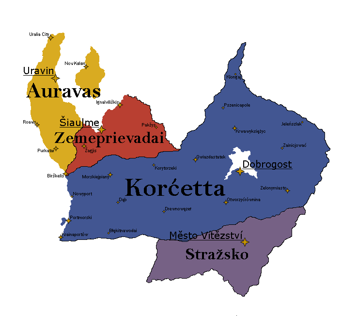
Hello, I would like Strazko to be changed from gray to a normal Urth color as they are no longer and anarchy and are rather a normal stable country. Thank you!
Hello,
I have finally sorted where I would like my cities located:
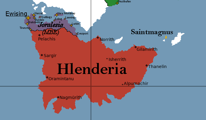
I am not sure what the cutoff is for the different sizes of stars, but this is how they are organized by population:
LARGE CITIES:
- Pelachis (capital of Hlenderia)
- Norrith (largest city)
- Oramintanu
MEDIUM CITIES:
- Gilamirith
- Thanelin
- Sargir
SMALL CITIES:
- Nagmūrith
- Isherrith
- Alpumachir
Thanks in advance!

Hello there,
I was wondering whether I could have Thøn’s population and GDP changed.
Population: 9,891,348 (Old=7,341,295)
GDP: $1,069,227,319,766.04 (Old=$793,573,654,112.85)
GDP Per Capita: $108,097.23 (Unchanged)
Thanks in advance!
Heh, hi again… This is very embarrassing, but I have noticed one more mistake on my part… Baat Küssen has two S’s, which goes against my orthography rules, and I somehow overlooked this both previous edits. I noticed that the map hadn’t updated yet so I thought to squeeze in this minor change before the next round.
You can find the mistake at coordinates 6470, 1612.
Hello Carto Friendos,
I have some map change requests. Two of them are very basic, but three of them are slightly more involved, so if you have any concerns/want to talk to me more about them, please do let me know.
The two basic ones are:
- Please rename the city Nežendrís in Metradan to Nezhendris, I was spelling it the wrong way this whole time
- Please move the city Nandrat in Tavaris so that it is on the border with Acronis, as pictured below
The other ones involve making changes to the physical map that I’ve been thinking about for some time. I’m more than happy to accommodate if the cartos want to make changes to the shapes, and I totally understand if you’d prefer not to make the changes, since it would be another thing that needs to be changed on other maps as well. However, since it seems like things like the climate and topo maps are being looked at right now, I felt like now was a good time to ask.
- I would like to make some changes to King’s Island so that it is smaller, closer to Tavaris, and now part of its own little archipelago with some smaller islands nearby. I drew the islands on the included map to preserve Tavaris’ number of pixels.
- I have moved Nuvrenon a little bit, but this change is only necessary if you approve the request to change the island.
- I would like to add two lakes to Metradan. I don’t actually know if the cartos have a policy when it comes to whether or not lakes are visible, but I came up with these lakes as part of a major river system for Metradan that is a major reason why it’s very swampy and it seemed that, if these lakes did exist, they would be big enough to be mapped.
The attached XCF file has layers with the exact shapes of the islands and lakes.
Thank you so much for your time!
modest proposal 2.xcf (3.3 MB)
Hi all.
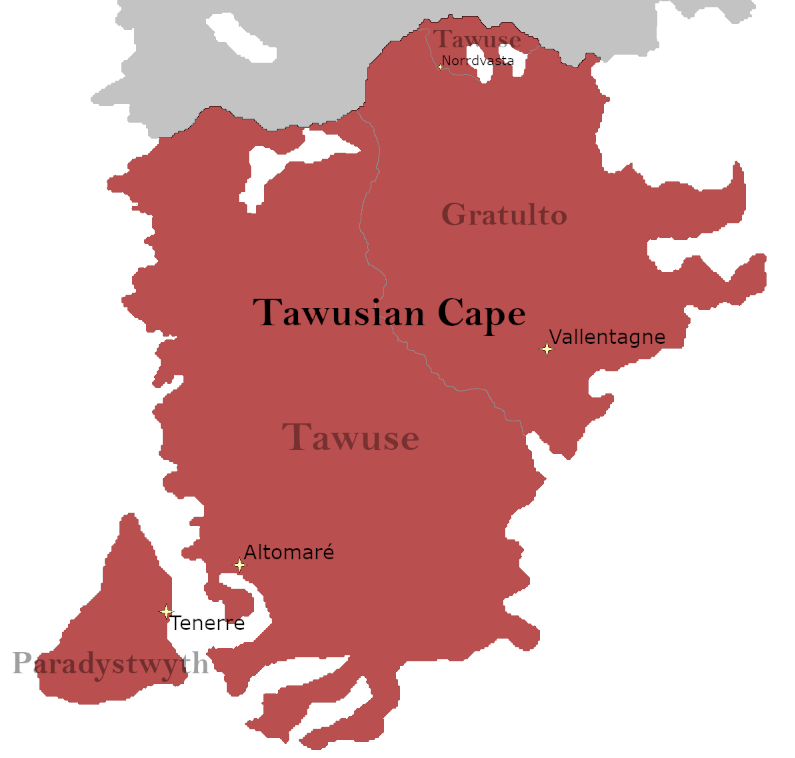
I have an exciting map change following a referendum in Tawuse (Click here).
Following this referendum, Tawuse is to change its name to The Tawusian Cape. There is no external border changes to the Cape. However, internally, The Tawusian Cape consists of three federalised states that (if possible) I would like to be displayed (See attached screenshot).
Specifically, there are three states: Tawuse, Gratulto and Paradystwyth, all with their respective capitals that I would like to be displayed. Additionally, Tawuse has territory at the North of Gratulto, which I have marked with the city of Norrdvasta for reference.
Other than these internal border changes, all cities on the current map haven’t changes.
On an international level, the states act as one with the same currency. The overall population of the Cape is not different to that of the original claim of Former Tawuse. Wikis etc will be updated in weeks to come as my work allows.
Thank you for your time!
Phos
Hiya guys! When adding Aranthia to the map, can I ask that these cities be added with it? Thamk u!!! :333
Howdy Cartos, can you change the map label for ‘Southern Coast’ to ‘Lapérouse.’ Please and thank you in advance!
1 Like
I would like I’m Dead to adopt Auravas
I would like to accept the adoption request
Hey all, after the coastal change, I’m editing the position of cities in my Gondwanan nations. Here’s the change, thank you!
New Kaskada.xcf (120.9 KB)
Hi there! I am here to request a decent stat change for Helslandr, its a rather big one since I haven’t done it since the end of the civil war
Just reminder, prior to the civil war Helslandr’s Population was around 22 million people, with 18 million people being there now. Gdp wise unless i am incorrect their gdp was at 450 billion, it is now at 140 billion.
With it being two years since the civil war, with Helslandr getting massive amount aid from the Bassot Plan and with refugees returning back. I’d like a stat increase for Helslandr. So here the stat request:
Population: 18,001,366 → 19,100,095
Gdp: 140 billion → 160 billion
Gdp per capita: 7,777 → 8,377
Approved without vote (for record-keeping purposes)
Hey Cartos!
I am changing the location of the city of Castralanza, and I would like for it to reflect on the map, thank you!
New Castralanza.xcf (2.4 MB)
Removal pls
Hey Cartos!
I’m panning a reset for 2025, please could I have both Wealden and Aranthia wiped from the map? ![]()
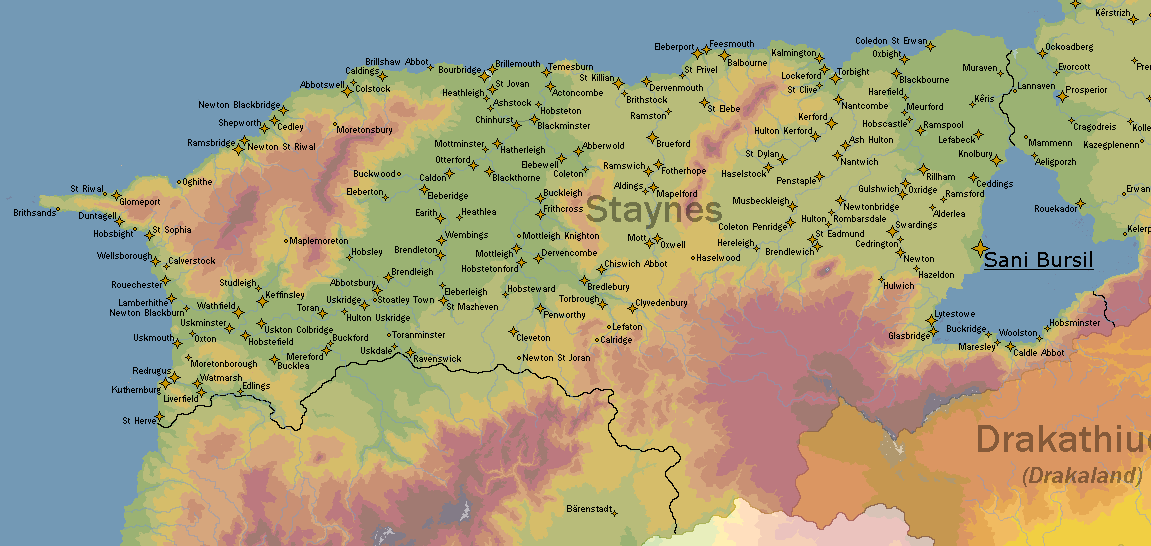
Good morning world.
Please may this map I have supplied supercede the current city loadout for Staynes. This means that all cities except Sani Bursil, Kuthernburg and Redrugus will be removed, and quite a few others will take its place.
This has been a project that I have dedicated many hours into, researching Old English, some Germanic, and Breton toponymic language roots, then learning and plotting the rivers, and plotting the cities based on this. I have an Excel document recording their populations and how many constituencies each city is afforded, as well as the overall urbanisation rate in Staynes, that data will assist me in future mapping and charting.
Whilst I have only recorded the etymological meaning for 30 of these cities, feel free to ask me the meaning of any in particular and I’ll work it out.
I will attach an XCF file for the city layer under the preview image, hopefully that helps.
Many thanks.
Staynish cities.xcf (59.7 KB)
I would like to have Gong adopt Lunsesara from me.
1 Like