I agree to adopt Lunsesara!
1 Like
Hello cartographers! Since I did the new nation claim for Gemeinschaftsland, it’s undergone some very substantial lore changes. The gist of it is: after 1921, the country rapidly modernizes technologically and economically over the span of 80-100 years, and after 1942, reforms into a Confederation. (If you would like more details on how the lore has changed, I can provide them).
In keeping with the change of lore, I’d like to request adjusting the following stats upward:
Population: 6,000,000 → 13,200,000
GDP total: 270,000,000,000 → 610,315,000,000
GDP Per Capita: 45,000 → 46,236
I understand that these changes are quite substantial, and am willing to adjust further. If that is necessary, lmk.
Then there should be the following map change. Gemeinschaftsland should be renamed to the Confederation of Southwest Gondwana, with the following subdivisions: (cities remain the same, except Lutrynestadt, Nowy Portmorski, and Readweald should be given capitol stars, in addition to Violett)
Gemeinschaftsland
Lutrynestadt
Krogów
Fiergenfot

Thank you!

Hi there! With the how things developed in Mkænian War, with IF cease fire and general situation is right now. I would like this area to be coloured gray to represent it was a disputed territory called Mkæniszna. For information about it, for those interested context and lore:
https://tep.wiki/wiki/Mkænian_War
I forgot to mention but I also wanted cities be added into this. Mkænby is the red dot, which is the capital, though because disputed territory just make it normal city size. Yellow dot is Mkænborg.
Hello fellow Cartos!
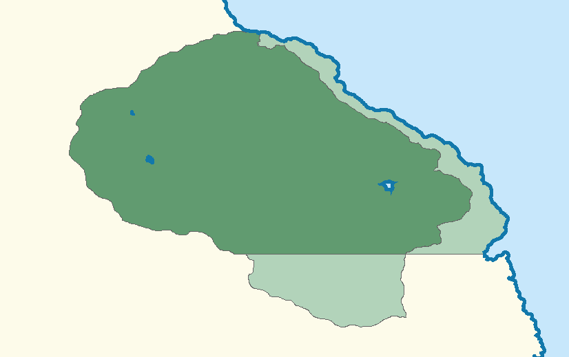
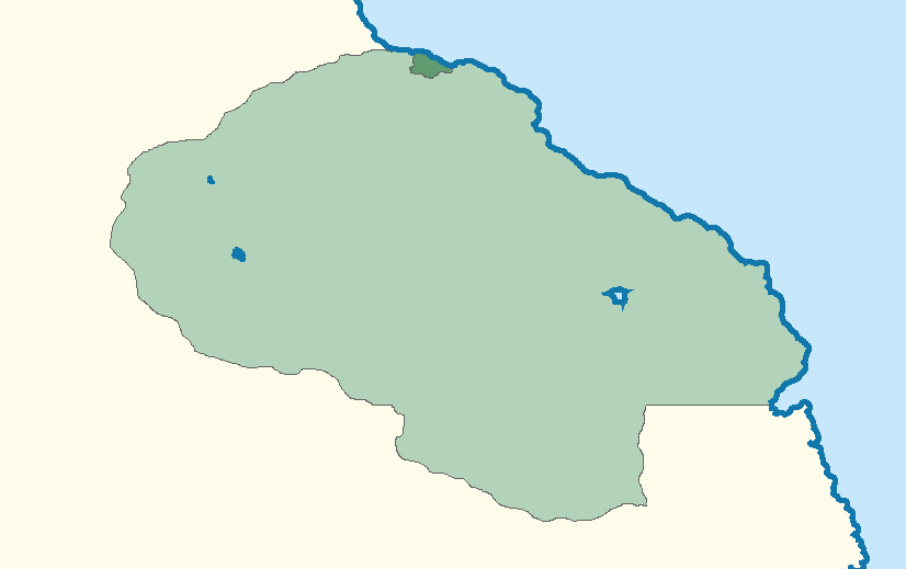
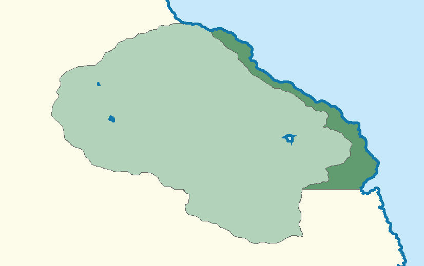
Because of the Aurora rework and some lore rework, I would like to change Tarelia’s stats.
Area Change:
432994.15 km² → 635705.32 km²
Population:
14,754,490 → 21,661,973
GDP Per Capita:
$15,175 → $35,789
GDP:
$223,855,122,280 → $775,260,351,697
Thank you!
Your stat change has been APPROVED on January 16th with a vote of 6-0-0.
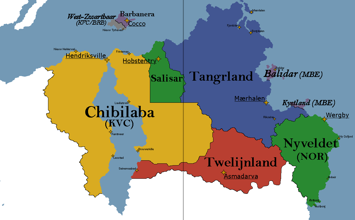
Alteration to the Western Borders of Vistari North Gondwana (Chibilaba) alongside minor movement of cities which was agreed to happen following the redraw of NE Gondwana in June 2024. Yes, that was half a year ago. I only just remembered to do it. Any minor refinements are welcome (except that one straight line I put in, that’s my emotional support colonial border line). No nation-level stat changes beyond minor changes to land area. Copy of the SVG sent in the cartography channel.
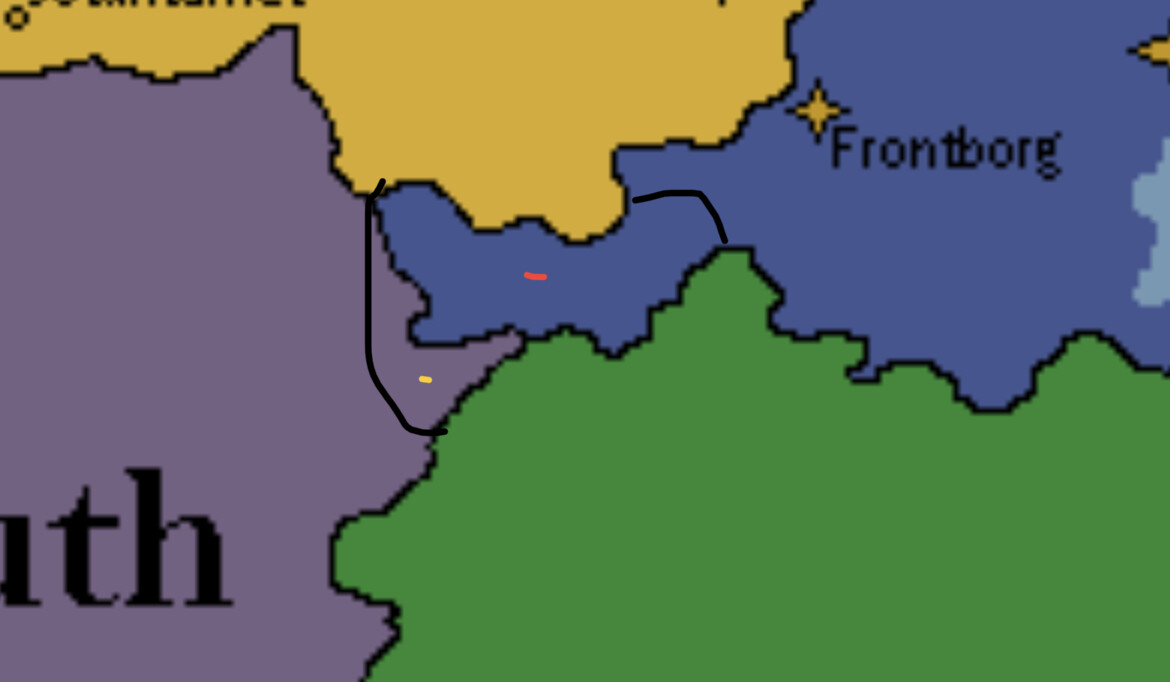
Hello! I have a bit of a strange problem regarding Reijia One of the core components of its lore is that it has control over the strait that it’s in. That’s how it’s high gdp per capita and strong international influence was justified. This was fine until a nation named Esmir claimed the area around Reijia and threw Reijia’s canon into question. Luckily, Vire, the person behind Esmir, didn’t do much with the nation, but if things had gone differently, Esmir could have claimed ownership over the strait and thrown Reijia’s lore out the window, and I would have been unable to stop it because Esmir technically does control a large part of the strait. Vire has been inactive long enough for Esmir to be removed, but it doesn’t really fix the core problem as someone else could just claim the area around Reijia and reignite the problem. I really don’t like the sort of pseudo-canon position that Reijia sits in right now, so I’ve come here to try and settle it once and for all. Here is my preferred solution for fixing the problem:
- A coastline change to the areas within the strait to make Reijia’s ownership of the strait clear. I believe this to be the best option because I don’t have to turn Reijia into a snake by stretching it from one end of the strait to the other, and since its unambiguous it won’t bring up issues in the future.
Here is a drawn up version of my preferred solution:
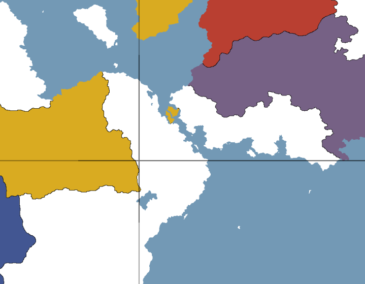
(The Red Dot is where I want Khaj to be!)

Turtle has bribed me so he owes me this, but since there are non-turtle people in Cartography I will put this claim through the process of minor territorial expansions used for small islands (ie. Vorpest and Blokkarim). I intend to create a similar page of similar size and scope to Blokkarim in the near future (acknowledging I will also be working on other projects and my Dissertation) should this claim be accepted, though I note it exists out of spite and the bit. It is called Dyland because that was part of the deal.
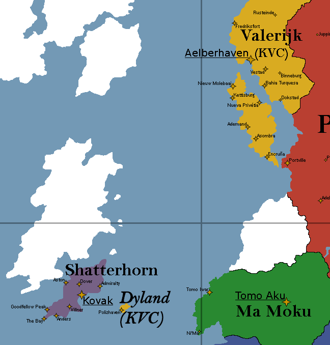
Autonomous Dominion of Dyland
Autonoom Dominion van Diedeland (Vistarian)
Autonoom Domyn fan Tiedelan (Dyer Creole)
Motto: “Ingenieusheid, Gearwurking, Ekonomy” (Ingenuity, Collaboration, Economy)
Anthem: Along The River Vistara
Sovereign State: Vistaraland
Colony established: 1667
Dominion status: 1701
Confederated Colonies of Valerijk: 1795
Separated from Valerijk due to island’s corruption and calls for local autonomy: 1831
Accession to the Imperial Vistari Confederation: 24 December 2020
Capital and largest city: Polizhaven
Official languages: Vistarian, Dyer Creole, Impelanzan, Cukish, Alkari, Codexian, Kolonital, Noorvic
Demonyms: Dyer, Dieder
Government: Devolved legislature under a constitutional monarchy
Queen: Marium I
Governor: Tjebbe Meulenbelt (National Progressive Bloc)
Captains-General:
- Harrie Ulers (Volgerisser Sapientarian Union)
- Jalkje Stoker (Republican Action Party)
- Alie Sikkes (Independent)
Lord Advisors:
- Ritsger Bloemsma (National Progressive Bloc)
- Steef Hekmans (Volgerisser Sapientarian Union)
Representatives: 24 Representative-Advisors
Legislature: Island Parliamentary Council
Population: 56,192
GDP:
- Nominal: $1,358,099,952.64
- Per Capita: $24,168.92
Currency: Vistari Gildemerk, South Hills Dollar
Historical Summary
The Autonomous Dominion of Dyland (Vistarian: Diedeland, Dyer Creole: Tiedelan) was a territory colonized by the Vistari Empire during the period referred to as the Vistari Golden Age - where the system of triangular trade has greatly enriched the colonial elite of Valerijk thus allowing for considerable investment across the Concordian. Settled by the Vistari Colonial Company upon orders from Governor Bartje Diedrich of Katoemia, a key figure within the government of the Federative Dominion of Nieuw Molensland, the island was originally intended to be used for the growing of indigo and tobacco, however early efforts to subjugate the native population proved ineffective and the yield of plantation settlements failed. Now an unruly territory which would not be well-equipped to handle the importation of Gondwanan slave labour, instead the island became used primarily as a trading hub, docking site and centre for cultural exchange on the passage between Valerijk and Gondwana. The native population would be slowly subjugated and forced to integrate or have their lands confiscated, creating a hybrid Tiedyer culture from those who would partially assimilate into a creole speaking elite who would assist the Vistari in governance in exchange for cultural concessions and access to economic opportunity.
However, with this development came the island’s wider perception of corruption and a lack of Imperial oversight, with the Tiedyer administrative class often chosen based on patronage and convenience for the Valerijkian elites while the interests of the VCC and other mercantile companies on the island would be allowed to freely consolidate power. This would become especially notable with the centralization of Valerijk’s governance, where the island would often serve as a safe haven for charlatans, gamblers and traders of stolen goods to operate. The island would be admitted to the Confederated Colonies of Valerijk in 1795, yet Valerijkian authorities, whether out of inability or negligence, were not able to get a hold of corruption in the territory and would struggle to enact Confederation laws on a detached territory with considerable local resistance. The island was forcibly separated from the Confederation in 1831.
Following its assertion as a separate, autonomous dominion, crime and the associated corruption would be swept into the background and the social order of Vistari elites, Tiedyer collaborators and offshore investors would be enshrined into a system of government which granted parliaments to legislate Vistari, Tiedyer and Business affairs as separate communities. In the modern day the island has a large tourism sector due both to its location and a lax legal system supported by casinos, dispenseries and a number of red-light districts.
Political Parties:
National Progressive Bloc (Big tent):
- Regionalism
- Populism
- Economic liberalism
- Vistari unionism
Dyer Libertarians (Centre to Centre-right):
- Libertarianism
- Laissez-faire economics
- Classical liberalism
- Vistari unionism
Ecological Development Party (Centre-left)
- Green liberalism
- Social liberalism
- Sustainable development
- Anti-nuclear
Party of Workers and Citizens (Centre-left to left-wing)
- Social democracy
- Green politics
- Progressivism
- Regionalism
Vistarian Parties:
Volgerisser Sapientarian Union (Centre-right)
- Volgerisser pluralism
- Social conservatism
- Social capitalism
- Vistarian unionism
Vistarian Social Equality Party (Centre-left):
- Populism
- Labourism
- Social conservatism
- Vistari unionism
Dyer Conservative Party (Right-wing):
- Conservatism
- Royalistic populism
- Vierist democracy
- Vistari unionism
Tiedyer Parties:
Republican Action Party (Far-right):
- Tiedyer nationalism
- Dyer independence
- National conservatism
- Republicanism
Tiedyer Collaboration Party (Centre):
- Conservative liberalism
- Agrarianism
- Regionalism
- Tiedyer minority interests
Movement for Popular Rule (Left-wing):
- Tiedyer nationalism
- Dyer independence
- Democratic socialism
- Social conservatism
This map change has been accepted by a vote of 6-0-0
This map change has been accepted by a vote of 6-1-0
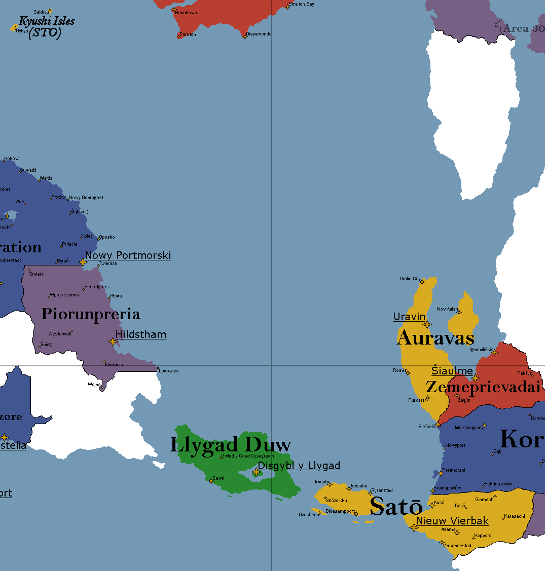
Adoption of Satō with provision for implementing ideas collaboratively should a revisit be desired. Proposal made following mutual agreement with Ark.
Additionally, moving of Sato’s location upon suggestion and mutual agreement with cartographers and approval from Ark. If it is possible I would very much like the nation to remain gold as to remain in-line with Vistaraland for the purposes of associated status.
Hi there, so here’s a map of both the counties and the main cities of the Limboese Republic. If you think it’s possible, please add them to the map (I hope it can be seen from the image).
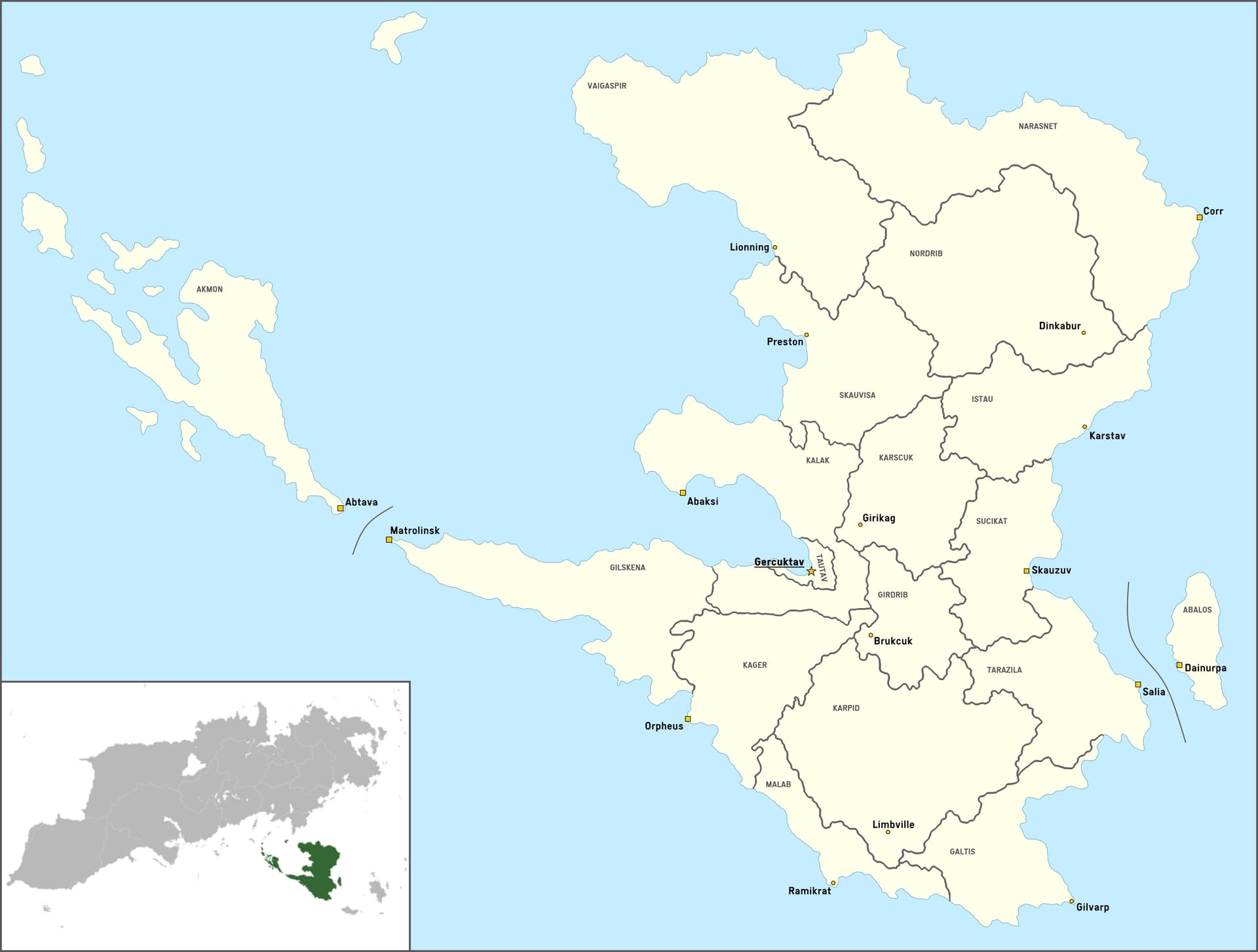
I also added the location of Limbo relative to Aurora since I saw it isn’t marked on the map yet (for the color of the nation you can use any color, though I’d appreciate if it was a shade of blue or purple - like the nation’s flag).
That’d be all ◝(ᵔᗜᵔ)◜
The cities will be added, but the subdivisions are too small to fit on our map (feel free to use them on your own maps though).
1 Like
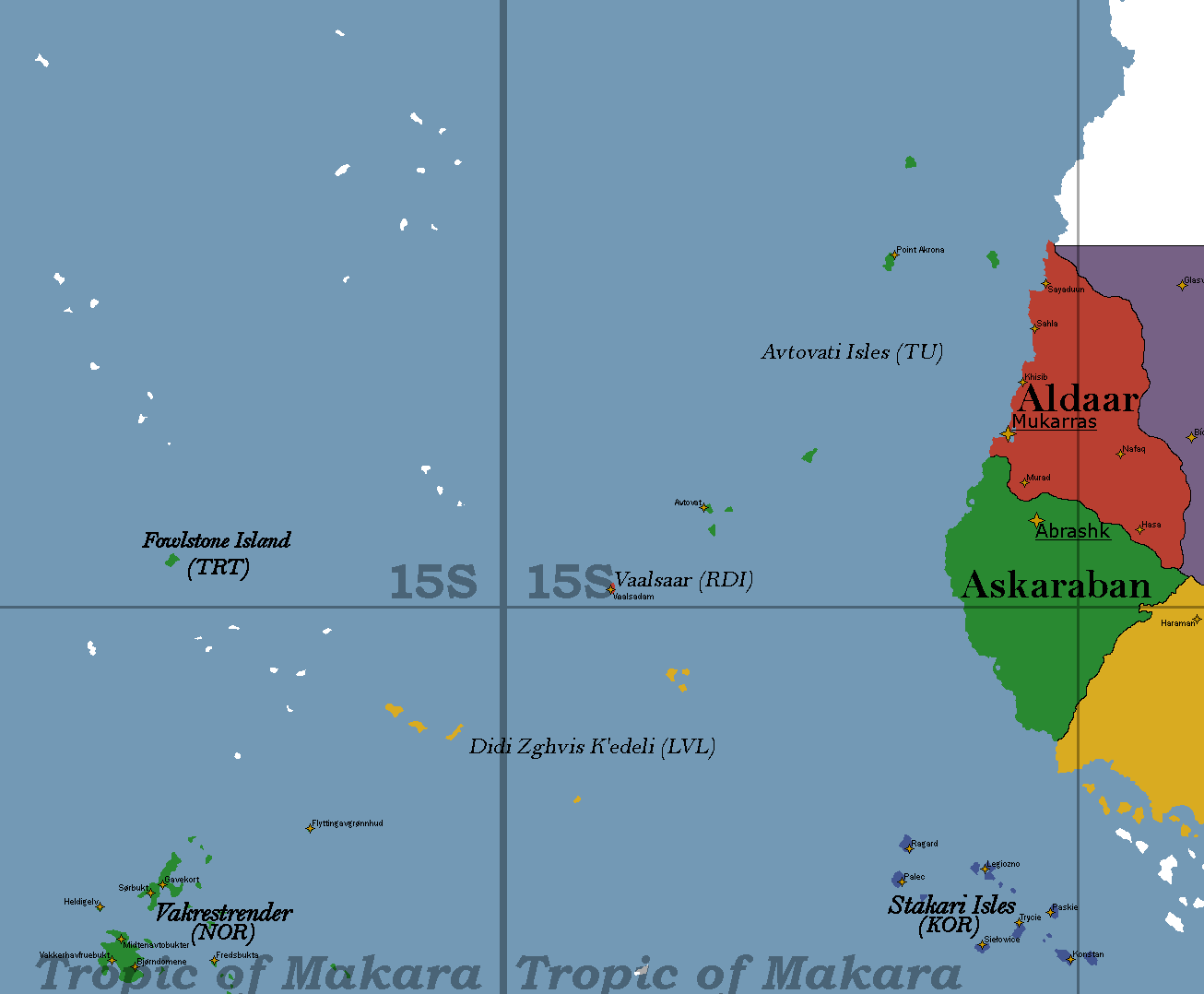
Hello Carto Friends,
I am requesting that some territories be relocated on the map: the Avtovati Isles, Vaalsaar, and Didi Zghvis K’edeli. (Note: I do not own Didi Zhgvis K’edeli, it belongs to Tuva, but because Salovia bought those islands from Tavaris, moving the Avtovati Isles necessitates moving Didi Zghvis K’edeli as well. Please seek Tuva’s approval before relocating the islands.)
The Avtovati Isles were intended to be along the route from Tavaris to Aurora. However, with sea currents/winds having since been detailed more, it turns out that they currently are not on such a route. I am seeking to place them somewhere closer to my original intention. However, they remain in the same region of the map, so they can still enjoy close economic relationships with Sayyed and Korcetta’s Strakari Isles as they currently canonically do.
Each territory will now take fewer pixels on the map than they did previously:
Avtovati Isles: were 835px, now 752px
Vaalsaar: was 94px, now 49px
Didi Zghvis K’edeli: was 684 px, now 632px
I am also requesting the name of the city “Mt. Akrona” be changed to “Point Akrona.”
Please note this map is centered on the Cerenerian Ocean. Didi Zghvis K’edeli will now cross the Anti-Meridian and exist on both edges of the map.
Thank you!
Hello all,
Apologies for my inactivity as of late, however now with things settling down for me I would like to get back into doing some more roleplays. I’ve kind of lost interest in managing two completely different neighbouring and I’d like to focus on East Cerdani and Chianski and their interactions regionally and internationally as well as their domestic politics.
As such I’d like to request that West Cerdani be removed entirely, along with the neutral zone between East and West, as it serves no purpose anymore. Alternatively I am also okay with it being put up for adoption, but either option works for me.
If West Cerdani is removed could East Cerdani simply be renamed to Cerdani or Cerdani D.R as there would be no need for the “East” distinction anymore.
I would also like to adjust East Cerdanis stats, mostly reducing the population from 120 million to 95 million or so and adjusting the GDP downwards to account for the population shrink.
Hello!
Sorry for this, but I decided to change the map names of the Limboese cities, so here’s a map with the new names (the ones in CAPS, the dots are just smaller towns).
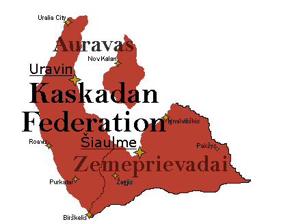
Hello!
I have reached the part in my RP where Auravas and Zemeprievadai have combined into one nation, the Kaskadan Federation. Here are the links to the wiki page and RP:
RP: The Red Sun Rises - #4 by American-Cascadia
Wiki: 2024 Kaskadan Unification Referendums - TepWiki
Here are the new stats:
Pop: 24,088,520
GDP: 788,571,300,000
GDP Per Capita: $32,736.39
Here is the PNG and XCF maps as well:
Kaskadan Federation.xcf (58.2 KB)
Thank you!
Dear cartos,
I’ve had ideas for perfecting the concept of Wed Shams, including the present request for a tiny expansion (red line). Before moving Wed Shams to its current location, I wanted to make it look like a Gambia of sorts: a country articulated around a massive river and divided between the fluvial and coastal regions (with some bits of desert around the north). With this retcon it also can provide some room for interesting Puntalia-Wed Shams connections, among which is the possibility (not before making sure about its geographic viability) of a Mississippi-Missouri situation that explains why the Shams river is so long and wide and why it carries so many sediments.
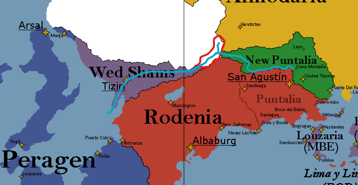
Please hit me up for anything you need about this ![]()
Hello!
While I was working on the city populations for Limbo, I noticed that the total population would’ve been in majority (as in over 70%) represented by the urban area, so I decided to change the population of Limbo (aka the Limboese Republic). Below are some statistics:
Statistics of Limbo's population
Current Population (CrP): 7,969,823
New Population (NwP): 10,923,989
Change: 2,954,166 (+37%)
Urban population: 6,237,598 (78.26% CrP; 57.1% NwP)
Rural population (CrP): 4,686,391 (42.9%)
Rural population: (NwP): 1,732,225 (21.7%)
Area (estimated): 985,854.7 km2 (380,640.6 sq mi)
I have added the area because I wanted to show the comparison between Limbo’s area and current population. Thank you!